Santa Catarina del Monte night lights from space
Night Light of Santa Catarina del Monte (México) from space (Mexico) Src. Average luminocity for 10x10km area is 44.9731% and for 50x50km: 44.7987%.
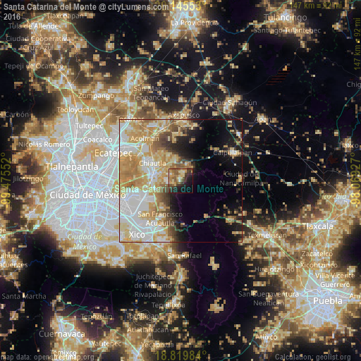
Analysis of Santa Catarina del Monte night lights 2016
Square area 10x10 km:
 0.83%
0.83%90-99
4.55%80-89
12.4%70-79
6.82%60-69
9.09%50-59
11.36%40-49
6.61%30-39
10.54%20-29
10.33%10-19
17.36%0-9
10.12%Square area 50x50 km:
9.9%90-99
8.22%80-89
9.54%70-79
9.26%60-69
6.62%50-59
3.82%40-49
3.64%30-39
2.81%20-29
3.71%10-19
9.08%0-9
33.4%Clear (daylight) street map image can be seen on geolist.org.
Map coordinates:
20° 8' 43.9" North, 99° 28' 31.9" West
19° 29' 2.5" North, 98° 46' 20.6" West
18° 49' 11.4" North, 98° 4' 9.4" West
Some cities around Santa Catarina del Monte sort by population:
• San Miguel Coatlinchán
11.2 km =7 mi,  250°
250°
• San Miguel Tlaixpan
4.9 km =3 mi,  305°
305°
• San Joaquín Coapango
8.5 km =5.3 mi,  317°
317°
• San Jerónimo Amanalco
4.1 km =2.5 mi,  23°
23°
• Tepetlaoxtoc de Hidalgo
11.1 km =6.9 mi,  334°
334°
• Tequexquináhuac
5.5 km =3.4 mi,  262°
262°
• Xochimanca
5.5 km =3.4 mi,  277°
277°
• Xocotlán
8.5 km =5.3 mi,  294°
294°
3517685 (p: 5,599)
Sources (retrieved 2019-11-25):
» Earth at Night: Flat Maps 2012, 2016