Vista Hermosa night lights from space
Night Light of Vista Hermosa (México) from space (Mexico) Src. Average luminocity for 10x10km area is 99.312% and for 50x50km: 78.2194%.
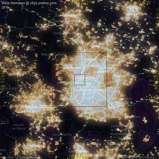
Analysis of Vista Hermosa night lights 2016
Square area 10x10 km:
 79.13%
90-99
18.39%80-89
2.48%70-79
0%60-69
0%50-59
0%40-49
0%30-39
0%20-29
0%10-19
0%0-9
0%Square area 50x50 km:
42.11%90-99
12.77%80-89
9.57%70-79
7.86%60-69
4.95%50-59
3.62%40-49
3.29%30-39
2.8%20-29
5.34%10-19
4.55%0-9
3.14%Clear (daylight) street map image can be seen on geolist.org.
Map coordinates:
20° 10' 39.1" North, 99° 55' 35.3" West
19° 30' 58.2" North, 99° 13' 24.1" West
18° 51' 7.5" North, 98° 31' 12.8" West
Some cities around Vista Hermosa sort by population:
• Naucalpan de Juárez
4.5 km =2.8 mi,  202°
202°
• Tlalnepantla
4 km =2.5 mi,  47°
47°
• Cuauhtémoc
11.3 km =7 mi,  134°
134°
• Ciudad López Mateos
5.8 km =3.6 mi,  322°
322°
• Azcapotzalco
5.1 km =3.2 mi, 129°
• Miguel Hidalgo
9.4 km =5.8 mi,  165°
165°
• Colonia Lindavista
10.7 km =6.6 mi,  104°
104°
• Polanco
9.6 km =6 mi,  164°
164°
3514633 (p: 6,344)
Sources (retrieved 2019-11-25):
» Earth at Night: Flat Maps 2012, 2016