Villa Madero night lights from space
Night Light of Villa Madero (Michoacán) from space (Mexico) Src. Average luminocity for 10x10km area is 1.9483% and for 50x50km: 2.0078%.
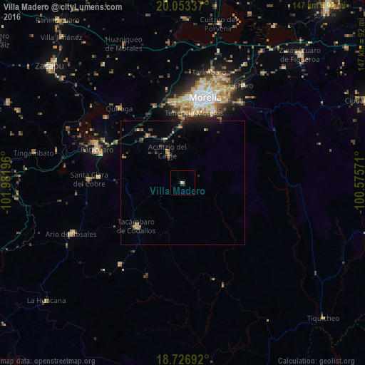
Analysis of Villa Madero night lights 2016
Square area 10x10 km:
 0%
0%90-99
0.62%80-89
0.21%70-79
0%60-69
0.83%50-59
0%40-49
0%30-39
0.83%20-29
0.83%10-19
0.83%0-9
95.87%Square area 50x50 km:
0%90-99
0.09%80-89
0.34%70-79
0.24%60-69
0.28%50-59
0.09%40-49
0.6%30-39
0.39%20-29
0.57%10-19
1.47%0-9
95.94%Clear (daylight) street map image can be seen on geolist.org.
Map coordinates:
20° 3' 12.1" North, 101° 58' 55.1" West
19° 23' 29.4" North, 101° 16' 43.8" West
18° 43' 36.9" North, 100° 34' 32.6" West
Some cities around Villa Madero sort by population:
• Morelia
35.8 km =22.2 mi,  16°
16°
• Tacámbaro de Codallos
25.6 km =15.9 mi,  227°
227°
• Morelos
28.9 km =18 mi,  8°
8°
• Conjunto Habitacional Villas del Pedregal
32.6 km =20.3 mi,  355°
355°
• Opopeo
34.3 km =21.3 mi,  273°
273°
• Acuítzio del Canje
12.9 km =8 mi,  333°
333°
• Pedernales
34.2 km =21.3 mi,  215°
215°
• Capula
33.5 km =20.8 mi,  339°
339°
3980152 (p: 6,577)
Sources (retrieved 2019-11-25):
» Earth at Night: Flat Maps 2012, 2016