Conjunto Habitacional Villas del Pedregal night lights from space
Night Light of Conjunto Habitacional Villas del Pedregal (Michoacán) from space (Mexico) Src. Average luminocity for 10x10km area is 47.6302% and for 50x50km: 15.4382%.
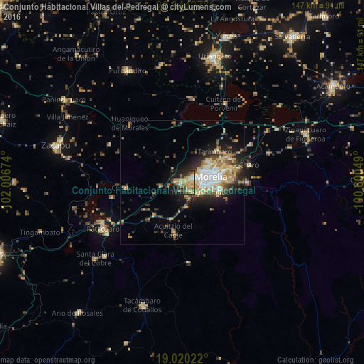
Analysis of Conjunto Habitacional Villas del Pedregal night lights 2016
Square area 10x10 km:
 2.89%
2.89%90-99
4.96%80-89
13.22%70-79
10.33%60-69
8.47%50-59
4.96%40-49
8.88%30-39
5.99%20-29
15.29%10-19
22.73%0-9
2.27%Square area 50x50 km:
1.89%90-99
2.4%80-89
2.7%70-79
2.38%60-69
2.66%50-59
1.19%40-49
2.53%30-39
2.17%20-29
4.31%10-19
6.57%0-9
71.2%Clear (daylight) street map image can be seen on geolist.org.
Map coordinates:
20° 20' 39.4" North, 102° 0' 24.3" West
19° 41' 1" North, 101° 18' 13" West
19° 1' 12.8" North, 100° 36' 1.8" West
Some cities around Conjunto Habitacional Villas del Pedregal sort by population:
• Morelia
12.6 km =7.8 mi,  81°
81°
• Morelos
7.8 km =4.8 mi,  119°
119°
• Fraccionamiento Misión del Valle
21.1 km =13.1 mi,  64°
64°
• La Aldea
18.8 km =11.7 mi,  69°
69°
• Tarímbaro
18.1 km =11.2 mi,  46°
46°
• Fraccionamiento Galaxia Tarímbaro
14.3 km =8.9 mi, 52°
• Fraccionamiento Metrópolis II
13.2 km =8.2 mi, 52°
• Capula
9.3 km =5.8 mi,  263°
263°
8858150 (p: 10,934)
Sources (retrieved 2019-11-25):
» Earth at Night: Flat Maps 2012, 2016