Opopeo night lights from space
Night Light of Opopeo (Michoacán) from space (Mexico) Src. Average luminocity for 10x10km area is 8.593% and for 50x50km: 3.9892%.
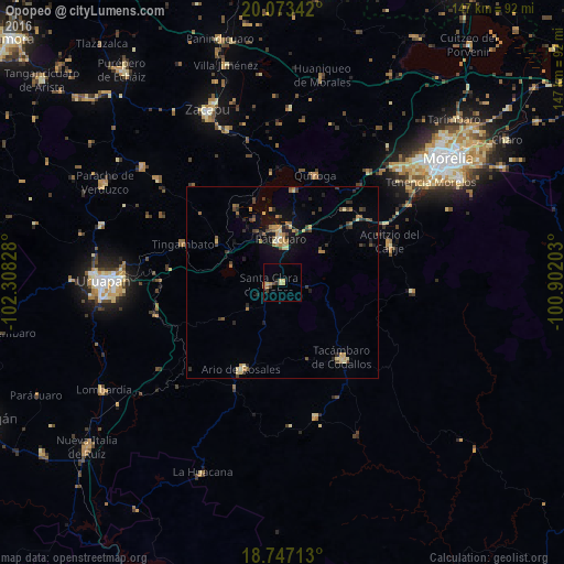
Analysis of Opopeo night lights 2016
Square area 10x10 km:
 0%
0%90-99
0%80-89
3.51%70-79
1.45%60-69
1.65%50-59
0%40-49
1.24%30-39
1.65%20-29
1.24%10-19
0%0-9
89.26%Square area 50x50 km:
0%90-99
0.15%80-89
0.86%70-79
0.65%60-69
0.74%50-59
0.28%40-49
1.09%30-39
0.7%20-29
0.94%10-19
1.88%0-9
92.72%Clear (daylight) street map image can be seen on geolist.org.
Map coordinates:
20° 4' 24.3" North, 102° 18' 29.8" West
19° 24' 41.9" North, 101° 36' 18.5" West
18° 44' 49.7" North, 100° 54' 7.3" West
Some cities around Opopeo sort by population:
• Pátzcuaro
11.6 km =7.2 mi,  358°
358°
• Tacámbaro de Codallos
25 km =15.5 mi,  141°
141°
• Ario de Rosales
25 km =15.5 mi,  205°
205°
• Quiroga
29.5 km =18.3 mi,  16°
16°
• Santa Clara del Cobre
3.7 km =2.3 mi,  259°
259°
• Tingambato
27.8 km =17.3 mi,  290°
290°
• Acuítzio del Canje
30 km =18.6 mi,  71°
71°
• Pedernales
33.3 km =20.7 mi,  154°
154°
3994164 (p: 10,055)
Sources (retrieved 2019-11-25):
» Earth at Night: Flat Maps 2012, 2016