Pedernales night lights from space
Night Light of Pedernales (Michoacán) from space (Mexico) Src. Average luminocity for 10x10km area is 1.2056% and for 50x50km: 0.7974%.
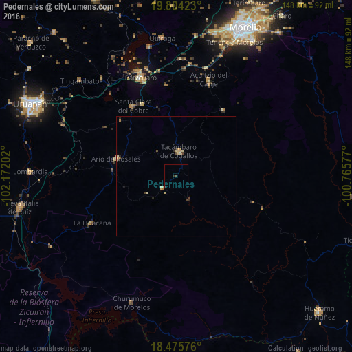
Analysis of Pedernales night lights 2016
Square area 10x10 km:
 0%
0%90-99
0%80-89
0%70-79
0%60-69
0%50-59
0.22%40-49
0.65%30-39
0.22%20-29
1.52%10-19
0%0-9
97.4%Square area 50x50 km:
0%90-99
0.04%80-89
0.29%70-79
0.15%60-69
0.08%50-59
0.04%40-49
0.2%30-39
0.06%20-29
0.29%10-19
0.03%0-9
98.82%Clear (daylight) street map image can be seen on geolist.org.
Map coordinates:
19° 48' 15.2" North, 102° 10' 19.3" West
19° 8' 28.8" North, 101° 28' 8" West
18° 28' 32.7" North, 100° 45' 56.8" West
Some cities around Pedernales sort by population:
• Tacámbaro de Codallos
10.5 km =6.5 mi,  6°
6°
• Ario de Rosales
26.2 km =16.3 mi,  286°
286°
• Santa Clara del Cobre
34.5 km =21.4 mi,  328°
328°
• Opopeo
33.3 km =20.7 mi, 334°
• La Huacana
40.7 km =25.3 mi,  240°
240°
• Puruarán
7.5 km =4.7 mi,  228°
228°
• Acuítzio del Canje
41.9 km =26 mi,  19°
19°
• Villa Madero
34.2 km =21.3 mi,  35°
35°
3993155 (p: 6,131)
Sources (retrieved 2019-11-25):
» Earth at Night: Flat Maps 2012, 2016