Vicente Camalote night lights from space
Night Light of Vicente Camalote (Oaxaca) from space (Mexico) Src. Average luminocity for 10x10km area is 5.6446% and for 50x50km: 3.1269%.
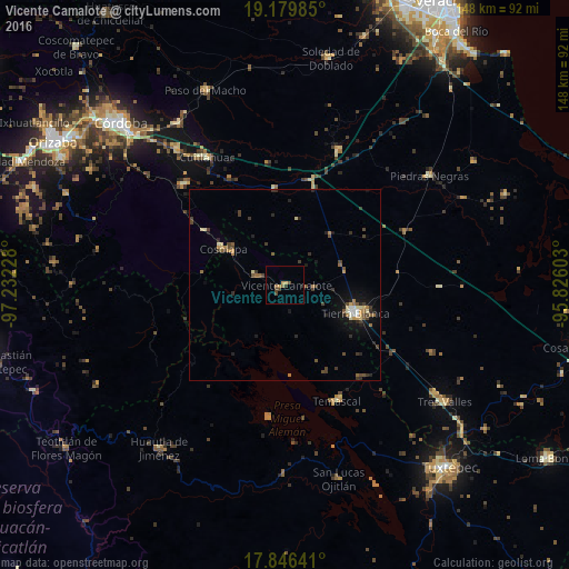
Analysis of Vicente Camalote night lights 2016
Square area 10x10 km:
 0%
0%90-99
0%80-89
0%70-79
2.27%60-69
1.03%50-59
1.03%40-49
2.48%30-39
0.83%20-29
1.03%10-19
0%0-9
91.32%Square area 50x50 km:
0.16%90-99
0.2%80-89
0.41%70-79
0.31%60-69
0.47%50-59
0.45%40-49
0.84%30-39
0.8%20-29
0.85%10-19
1.43%0-9
94.07%Clear (daylight) street map image can be seen on geolist.org.
Map coordinates:
19° 10' 47.5" North, 97° 13' 56.2" West
18° 30' 51.9" North, 96° 31' 44.9" West
17° 50' 47.1" North, 95° 49' 33.7" West
Some cities around Vicente Camalote sort by population:
• Tierra Blanca
19.4 km =12.1 mi,  112°
112°
• La Isla
41.1 km =25.5 mi,  76°
76°
• Cuitláhuac
39.1 km =24.3 mi,  328°
328°
• Cosolapa
19 km =11.8 mi,  300°
300°
• Isla Soyaltepec
35.2 km =21.9 mi,  172°
172°
• Temascal
33.1 km =20.6 mi,  155°
155°
• Acatlán de Pérez Figueroa
8.5 km =5.3 mi,  289°
289°
• Tezonapa
19.3 km =12 mi, 302°
3801271 (p: 7,164)
Sources (retrieved 2019-11-25):
» Earth at Night: Flat Maps 2012, 2016