Cuitláhuac night lights from space
Night Light of Cuitláhuac (Veracruz) from space (Mexico) Src. Average luminocity for 10x10km area is 17.1623% and for 50x50km: 6.71%.
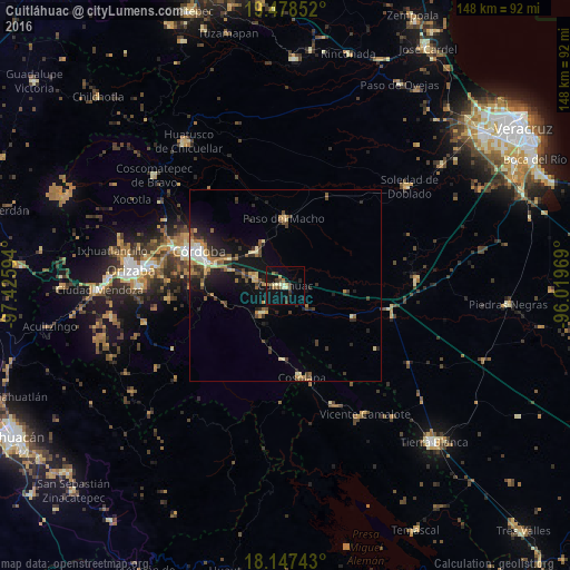
Analysis of Cuitláhuac night lights 2016
Square area 10x10 km:
 0%
0%90-99
2.38%80-89
3.03%70-79
1.95%60-69
1.08%50-59
3.46%40-49
2.38%30-39
4.33%20-29
3.03%10-19
16.88%0-9
61.47%Square area 50x50 km:
0.34%90-99
0.72%80-89
1.03%70-79
0.78%60-69
1.07%50-59
0.87%40-49
1.32%30-39
1.34%20-29
2.03%10-19
5.44%0-9
85.07%Clear (daylight) street map image can be seen on geolist.org.
Map coordinates:
19° 28' 42.7" North, 97° 25' 33.4" West
18° 48' 51.4" North, 96° 43' 22.1" West
18° 8' 50.7" North, 96° 1' 10.9" West
Some cities around Cuitláhuac sort by population:
• Córdoba
22.7 km =14.1 mi,  290°
290°
• General Miguel Alemán
11.4 km =7.1 mi,  320°
320°
• Paso del Macho
17.4 km =10.8 mi,  359°
359°
• Amatlán de los Reyes
20.6 km =12.8 mi,  280°
280°
• Cosolapa
24.1 km =15 mi,  170°
170°
• Yanga
8.2 km =5.1 mi, 284°
• Peñuela
18.8 km =11.7 mi, 287°
• Tezonapa
23.4 km =14.5 mi, 169°
3529911 (p: 13,651)
Sources (retrieved 2019-11-25):
» Earth at Night: Flat Maps 2012, 2016