Cosolapa night lights from space
Night Light of Cosolapa (Veracruz) from space (Mexico) Src. Average luminocity for 10x10km area is 11.0517% and for 50x50km: 3.0697%.
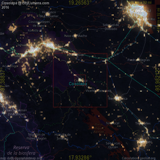
Analysis of Cosolapa night lights 2016
Square area 10x10 km:
 0%
0%90-99
1.24%80-89
2.07%70-79
1.65%60-69
2.48%50-59
1.65%40-49
3.72%30-39
1.24%20-29
0.83%10-19
0.83%0-9
84.3%Square area 50x50 km:
0%90-99
0.18%80-89
0.46%70-79
0.45%60-69
0.36%50-59
0.51%40-49
0.78%30-39
0.81%20-29
0.84%10-19
1.66%0-9
93.95%Clear (daylight) street map image can be seen on geolist.org.
Map coordinates:
19° 15' 56.3" North, 97° 23' 18.1" West
18° 36' 2" North, 96° 41' 6.9" West
17° 55' 58.3" North, 95° 58' 55.6" West
Some cities around Cosolapa sort by population:
• General Miguel Alemán
34.5 km =21.4 mi,  340°
340°
• Cuitláhuac
24.1 km =15 mi,  350°
350°
• Amatlán de los Reyes
36.6 km =22.7 mi,  318°
318°
• Vicente Camalote
19 km =11.8 mi,  120°
120°
• Zongolica
33.7 km =20.9 mi,  282°
282°
• Acatlán de Pérez Figueroa
10.8 km =6.7 mi,  128°
128°
• Yanga
28.4 km =17.6 mi, 335°
• Tezonapa
0.7 km =0.4 mi,  8°
8°
3530168 (p: 8,320)
Sources (retrieved 2019-11-25):
» Earth at Night: Flat Maps 2012, 2016