Isla Soyaltepec night lights from space
Night Light of Isla Soyaltepec (Oaxaca) from space (Mexico) Src. Average luminocity for 10x10km area is 0.5433% and for 50x50km: 1.4054%.
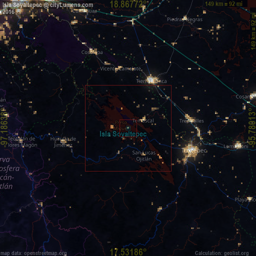
Analysis of Isla Soyaltepec night lights 2016
Square area 10x10 km:
 0%
0%90-99
0%80-89
0%70-79
0%60-69
0%50-59
0%40-49
0.87%30-39
0%20-29
0%10-19
0%0-9
99.13%Square area 50x50 km:
0%90-99
0.03%80-89
0.02%70-79
0.19%60-69
0.4%50-59
0.22%40-49
0.49%30-39
0.39%20-29
0.57%10-19
0.53%0-9
97.14%Clear (daylight) street map image can be seen on geolist.org.
Map coordinates:
18° 52' 3.8" North, 97° 11' 11" West
18° 12' 3.9" North, 96° 28' 59.7" West
17° 31' 54.7" North, 95° 46' 48.5" West
Some cities around Isla Soyaltepec sort by population:
• Tuxtepec
39.8 km =24.7 mi,  108°
108°
• Tierra Blanca
30.4 km =18.9 mi,  25°
25°
• Tres Valles
37 km =23 mi,  83°
83°
• Huautla de Jiménez
38.6 km =24 mi,  258°
258°
• Vicente Camalote
35.2 km =21.9 mi,  352°
352°
• Temascal
9.8 km =6.1 mi,  61°
61°
• San Lucas Ojitlán
18.3 km =11.4 mi,  150°
150°
• San Felipe Jalapa de Díaz
15.5 km =9.6 mi,  200°
200°
3801262 (p: 8,116)
Sources (retrieved 2019-11-25):
» Earth at Night: Flat Maps 2012, 2016