San José el Vidrio night lights from space
Night Light of San José el Vidrio (México) from space (Mexico) Src. Average luminocity for 10x10km area is 54.2087% and for 50x50km: 43.4602%.
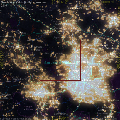
Analysis of San José el Vidrio night lights 2016
Square area 10x10 km:
 2.27%
2.27%90-99
3.51%80-89
14.46%70-79
13.02%60-69
16.12%50-59
7.64%40-49
7.64%30-39
10.12%20-29
14.88%10-19
9.92%0-9
0.41%Square area 50x50 km:
14.08%90-99
6.67%80-89
5.64%70-79
5.89%60-69
6.86%50-59
4.69%40-49
4.64%30-39
4.09%20-29
5.3%10-19
8.64%0-9
33.51%Clear (daylight) street map image can be seen on geolist.org.
Map coordinates:
20° 18' 50.8" North, 100° 5' 14.3" West
19° 39' 12" North, 99° 23' 3" West
18° 59' 23.3" North, 98° 40' 51.8" West
Some cities around San José el Vidrio sort by population:
• Nicolás Romero
8.2 km =5.1 mi,  99°
99°
• Veintidós de Febrero
6.1 km =3.8 mi,  139°
139°
• Progreso Industrial
3.4 km =2.1 mi,  123°
123°
• Santiago Cuautlalpan
10.6 km =6.6 mi,  71°
71°
• Villa del Carbón
11.8 km =7.3 mi,  315°
315°
• Quinto Barrio (Ejido Cahuacán)
5 km =3.1 mi,  225°
225°
• Santa María Magdalena Cahuacán
3.5 km =2.2 mi,  241°
241°
• Santa Gertrudis
9.1 km =5.7 mi,  11°
11°
3827476 (p: 5,204)
Sources (retrieved 2019-11-25):
» Earth at Night: Flat Maps 2012, 2016