Urireo night lights from space
Night Light of Urireo (Guanajuato) from space (Mexico) Src. Average luminocity for 10x10km area is 30.998% and for 50x50km: 13.6024%.
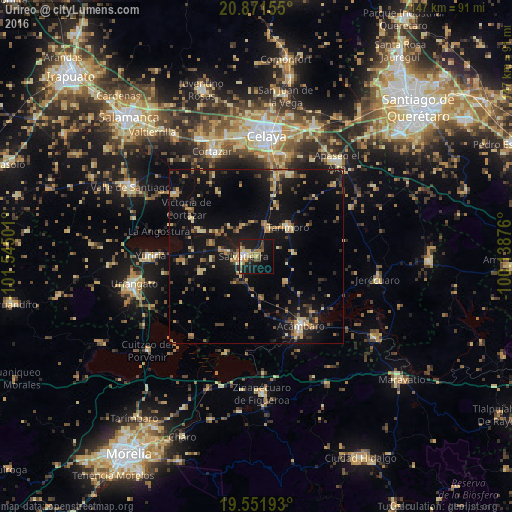
Analysis of Urireo night lights 2016
Square area 10x10 km:
 2.38%
2.38%90-99
3.97%80-89
6.15%70-79
5.56%60-69
3.97%50-59
4.37%40-49
3.37%30-39
2.18%20-29
5.95%10-19
38.29%0-9
23.81%Square area 50x50 km:
0.18%90-99
0.62%80-89
2.43%70-79
2.49%60-69
1.66%50-59
1.34%40-49
2.85%30-39
2.25%20-29
2.93%10-19
16.37%0-9
66.89%Clear (daylight) street map image can be seen on geolist.org.
Map coordinates:
20° 52' 17.6" North, 101° 32' 42" West
20° 12' 47.3" North, 100° 50' 30.8" West
19° 33' 6.9" North, 100° 8' 19.5" West
Some cities around Urireo sort by population:
• Acámbaro
23.8 km =14.8 mi,  148°
148°
• Salvatierra
4 km =2.5 mi,  270°
270°
• Jaral del Progreso
29 km =18 mi,  307°
307°
• Tarimoro
12 km =7.5 mi,  49°
49°
• Rincón de Tamayo
25.1 km =15.6 mi,  21°
21°
• San Nicolás de los Agustinos
13.5 km =8.4 mi,  285°
285°
• Santa Ana Maya
29.6 km =18.4 mi,  219°
219°
• Irámuco
29.2 km =18.1 mi,  196°
196°
4023831 (p: 8,679)
Sources (retrieved 2019-11-25):
» Earth at Night: Flat Maps 2012, 2016