Tarimoro night lights from space
Night Light of Tarimoro (Guanajuato) from space (Mexico) Src. Average luminocity for 10x10km area is 19.1091% and for 50x50km: 18.3877%.
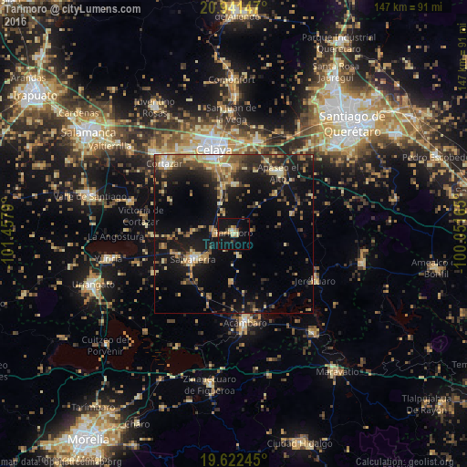
Analysis of Tarimoro night lights 2016
Square area 10x10 km:
 0.4%
0.4%90-99
1.19%80-89
4.37%70-79
4.56%60-69
0.99%50-59
1.98%40-49
1.79%30-39
1.59%20-29
1.39%10-19
36.9%0-9
44.84%Square area 50x50 km:
0.61%90-99
1.3%80-89
3.59%70-79
3.14%60-69
2.56%50-59
2.42%40-49
3.72%30-39
3.39%20-29
5.46%10-19
16.86%0-9
56.95%Clear (daylight) street map image can be seen on geolist.org.
Map coordinates:
20° 56' 29.3" North, 101° 27' 28.4" West
20° 17' 0.1" North, 100° 45' 17.2" West
19° 37' 20.8" North, 100° 3' 5.9" West
Some cities around Tarimoro sort by population:
• Celaya
27.4 km =17 mi,  346°
346°
• Acámbaro
28.3 km =17.6 mi,  173°
173°
• Salvatierra
15.2 km =9.4 mi,  239°
239°
• Apaseo el Alto
23.9 km =14.9 mi,  35°
35°
• Rincón de Tamayo
15.6 km =9.7 mi,  0°
0°
• Urireo
12 km =7.5 mi,  229°
229°
• San Nicolás de los Agustinos
22.5 km =14 mi,  259°
259°
• San José de Agua Azul
24.8 km =15.4 mi,  24°
24°
3982364 (p: 12,188)
Sources (retrieved 2019-11-25):
» Earth at Night: Flat Maps 2012, 2016