Rincón de Tamayo night lights from space
Night Light of Rincón de Tamayo (Guanajuato) from space (Mexico) Src. Average luminocity for 10x10km area is 41.5966% and for 50x50km: 30.8113%.
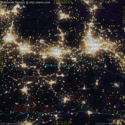
Analysis of Rincón de Tamayo night lights 2016
Square area 10x10 km:
 0.38%
0.38%90-99
2.27%80-89
10.04%70-79
10.61%60-69
7.58%50-59
5.3%40-49
9.66%30-39
9.66%20-29
13.07%10-19
25.38%0-9
6.06%Square area 50x50 km:
2.41%90-99
3.22%80-89
6.08%70-79
5.06%60-69
4.58%50-59
4.48%40-49
6.89%30-39
5.99%20-29
8.92%10-19
17.98%0-9
34.39%Clear (daylight) street map image can be seen on geolist.org.
Map coordinates:
21° 4' 51.4" North, 101° 27' 28.2" West
20° 25' 24.4" North, 100° 45' 16.9" West
19° 45' 47.2" North, 100° 3' 5.7" West
Some cities around Rincón de Tamayo sort by population:
• Celaya
12.8 km =8 mi,  330°
330°
• Cortazar
22.6 km =14 mi,  287°
287°
• Apaseo el Alto
14.5 km =9 mi,  74°
74°
• Apaseo el Grande
15.4 km =9.6 mi,  28°
28°
• San Miguel Octopan
16.8 km =10.4 mi,  2°
2°
• Tarimoro
15.6 km =9.7 mi,  180°
180°
• San Juan de la Vega
22.4 km =13.9 mi,  358°
358°
• San José de Agua Azul
12.5 km =7.8 mi,  55°
55°
3988648 (p: 10,324)
Sources (retrieved 2019-11-25):
» Earth at Night: Flat Maps 2012, 2016