Santa Ana Maya night lights from space
Night Light of Santa Ana Maya (Michoacán) from space (Mexico) Src. Average luminocity for 10x10km area is 6.506% and for 50x50km: 12.0885%.
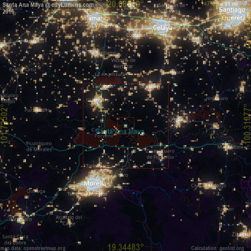
Analysis of Santa Ana Maya night lights 2016
Square area 10x10 km:
 0%
0%90-99
0%80-89
0%70-79
2.58%60-69
2.98%50-59
1.59%40-49
0.79%30-39
0%20-29
0.2%10-19
2.38%0-9
89.48%Square area 50x50 km:
0.27%90-99
0.73%80-89
2.18%70-79
1.97%60-69
2.08%50-59
1.5%40-49
2.31%30-39
1.67%20-29
2.92%10-19
10.51%0-9
73.86%Clear (daylight) street map image can be seen on geolist.org.
Map coordinates:
20° 39' 58.3" North, 101° 43' 30.1" West
20° 0' 24.8" North, 101° 1' 18.8" West
19° 20' 41.4" North, 100° 19' 7.6" West
Some cities around Santa Ana Maya sort by population:
• Uriangato
22.4 km =13.9 mi,  311°
311°
• Moroleón
22.1 km =13.7 mi, 306°
• Yuriria
25.4 km =15.8 mi,  333°
333°
• Cuitzeo del Porvenir
13.3 km =8.3 mi,  252°
252°
• Álvaro Obregón
20.8 km =12.9 mi,  185°
185°
• Estación Queréndaro
15.8 km =9.8 mi,  150°
150°
• Indaparapeo
25 km =15.5 mi,  167°
167°
• Irámuco
11.6 km =7.2 mi,  115°
115°
3984691 (p: 7,087)
Sources (retrieved 2019-11-25):
» Earth at Night: Flat Maps 2012, 2016