Tulum night lights from space
Night Light of Tulum (Quintana Roo) from space (Mexico) Src. Average luminocity for 10x10km area is 14.1151% and for 50x50km: 1.0667%.
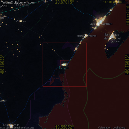
Analysis of Tulum night lights 2016
Square area 10x10 km:
 1.98%
1.98%90-99
2.58%80-89
2.18%70-79
2.78%60-69
1.19%50-59
0.79%40-49
1.19%30-39
0.6%20-29
1.79%10-19
1.59%0-9
83.33%Square area 50x50 km:
0.08%90-99
0.1%80-89
0.18%70-79
0.17%60-69
0.13%50-59
0.18%40-49
0.15%30-39
0.14%20-29
0.14%10-19
0.22%0-9
98.5%Clear (daylight) street map image can be seen on geolist.org.
Map coordinates:
20° 52' 12.5" North, 88° 9' 59" West
20° 12' 42.2" North, 87° 27' 47.7" West
19° 33' 1.9" North, 86° 45' 36.5" West
Some cities around Tulum sort by population:
• Playa del Carmen
61.1 km =38 mi,  40°
40°
• Cozumel
63 km =39.1 mi,  59°
59°
• Felipe Carrillo Puerto
93.1 km =57.8 mi,  220°
220°
• Chemax
69.8 km =43.4 mi,  315°
315°
• Puerto Aventuras
40.5 km =25.2 mi, 37°
• Leona Vicario
90.7 km =56.4 mi,  17°
17°
• Chichimila
91.4 km =56.8 mi,  300°
300°
• X-Cán
74.9 km =46.5 mi,  343°
343°
3515040 (p: 18,233)
Sources (retrieved 2019-11-25):
» Earth at Night: Flat Maps 2012, 2016