Puerto Aventuras night lights from space
Night Light of Puerto Aventuras (Quintana Roo) from space (Mexico) Src. Average luminocity for 10x10km area is 14.5606% and for 50x50km: 5.3971%.
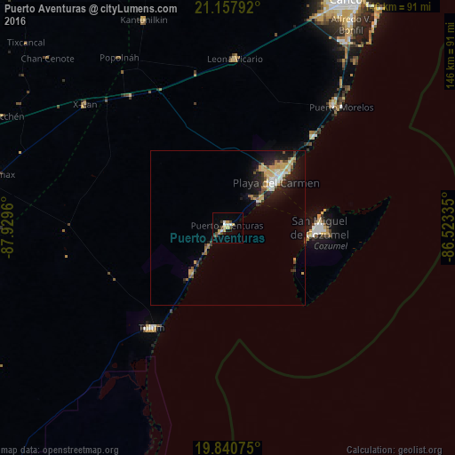
Analysis of Puerto Aventuras night lights 2016
Square area 10x10 km:
 1.7%
1.7%90-99
2.08%80-89
3.41%70-79
1.89%60-69
0%50-59
0.76%40-49
3.79%30-39
1.89%20-29
1.33%10-19
1.33%0-9
81.82%Square area 50x50 km:
0.49%90-99
0.66%80-89
1.48%70-79
0.71%60-69
0.28%50-59
0.55%40-49
0.63%30-39
0.73%20-29
1.38%10-19
3.88%0-9
89.22%Clear (daylight) street map image can be seen on geolist.org.
Map coordinates:
21° 9' 28.5" North, 87° 55' 46.6" West
20° 30' 2.7" North, 87° 13' 35.3" West
19° 50' 26.7" North, 86° 31' 24.1" West
Some cities around Puerto Aventuras sort by population:
• Playa del Carmen
20.8 km =12.9 mi,  47°
47°
• Cozumel
29.6 km =18.4 mi,  90°
90°
• Tulum
40.5 km =25.2 mi,  217°
217°
• Alfredo V. Bonfil
76.3 km =47.4 mi,  31°
31°
• Chemax
75.9 km =47.2 mi,  283°
283°
• Kantunilkín
72.1 km =44.8 mi,  337°
337°
• Leona Vicario
54.4 km =33.8 mi,  2°
2°
• X-Cán
60.8 km =37.8 mi,  310°
310°
6690747 (p: 5,979)
Sources (retrieved 2019-11-25):
» Earth at Night: Flat Maps 2012, 2016