Independencia night lights from space
Night Light of Independencia (Morelos) from space (Mexico) Src. Average luminocity for 10x10km area is 56.8766% and for 50x50km: 33.5032%.
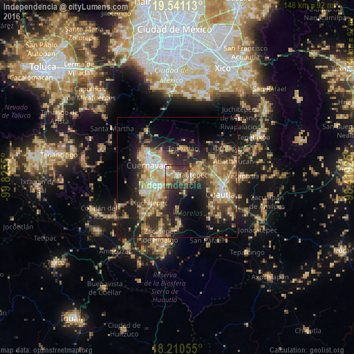
Analysis of Independencia night lights 2016
Square area 10x10 km:
 2.81%
2.81%90-99
4.33%80-89
15.15%70-79
10.61%60-69
10.82%50-59
4.98%40-49
27.27%30-39
11.04%20-29
12.99%10-19
0%0-9
0%Square area 50x50 km:
1.8%90-99
3.95%80-89
7.11%70-79
6.53%60-69
6.34%50-59
3.9%40-49
7.84%30-39
5.71%20-29
9.76%10-19
14.6%0-9
32.46%Clear (daylight) street map image can be seen on geolist.org.
Map coordinates:
19° 32' 28.1" North, 99° 49' 31.8" West
18° 52' 37.8" North, 99° 7' 20.5" West
18° 12' 38" North, 98° 25' 9.3" West
Some cities around Independencia sort by population:
• Jiutepec
5.8 km =3.6 mi,  274°
274°
• Emiliano Zapata
7.7 km =4.8 mi,  238°
238°
• Yautepec
5.8 km =3.6 mi,  84°
84°
• Tres de Mayo
9.1 km =5.7 mi,  263°
263°
• Progreso
3.2 km =2 mi,  275°
275°
• La Joya
1.5 km =0.9 mi,  355°
355°
• Los Arcos
10.4 km =6.5 mi, 83°
• Calera Chica
6.6 km =4.1 mi,  251°
251°
8858196 (p: 7,282)
Sources (retrieved 2019-11-25):
» Earth at Night: Flat Maps 2012, 2016