Tototlán night lights from space
Night Light of Tototlán (Jalisco) from space (Mexico) Src. Average luminocity for 10x10km area is 12.3011% and for 50x50km: 7.8368%.
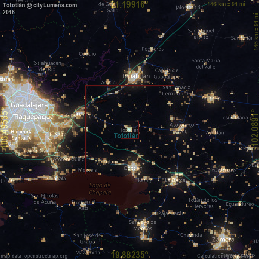
Analysis of Tototlán night lights 2016
Square area 10x10 km:
 0%
0%90-99
1.33%80-89
4.36%70-79
3.03%60-69
0.38%50-59
0.76%40-49
0.95%30-39
1.52%20-29
1.33%10-19
3.03%0-9
83.33%Square area 50x50 km:
0.19%90-99
0.63%80-89
1.33%70-79
1.16%60-69
0.97%50-59
0.6%40-49
1.85%30-39
1.38%20-29
1.71%10-19
4.99%0-9
85.2%Clear (daylight) street map image can be seen on geolist.org.
Map coordinates:
21° 11' 57" North, 103° 29' 43.3" West
20° 32' 31.8" North, 102° 47' 32" West
19° 52' 56.5" North, 102° 5' 20.8" West
Some cities around Tototlán sort by population:
• Ocotlán
20.9 km =13 mi,  174°
174°
• Atotonilco el Alto
29.5 km =18.3 mi,  88°
88°
• Jamay
29 km =18 mi,  162°
162°
• Poncitlán
22.8 km =14.2 mi,  217°
217°
• Acatic
29.2 km =18.1 mi,  335°
335°
• Cuitzeo (La Estancia)
22.2 km =13.8 mi,  177°
177°
• San Francisco de Asís
24.6 km =15.3 mi,  75°
75°
• San José de Gracia
27.4 km =17 mi,  57°
57°
3981165 (p: 12,516)
Sources (retrieved 2019-11-25):
» Earth at Night: Flat Maps 2012, 2016