Jamay night lights from space
Night Light of Jamay (Jalisco) from space (Mexico) Src. Average luminocity for 10x10km area is 14.3591% and for 50x50km: 8.5853%.
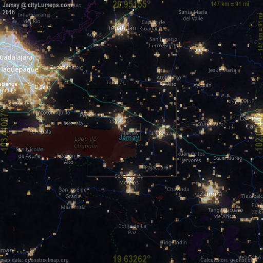
Analysis of Jamay night lights 2016
Square area 10x10 km:
 0%
0%90-99
0.2%80-89
4.56%70-79
1.59%60-69
1.39%50-59
0.4%40-49
3.97%30-39
2.78%20-29
2.78%10-19
16.07%0-9
66.27%Square area 50x50 km:
0.18%90-99
0.59%80-89
1.83%70-79
1.28%60-69
0.93%50-59
0.78%40-49
2.03%30-39
1.58%20-29
1.46%10-19
7.15%0-9
82.17%Clear (daylight) street map image can be seen on geolist.org.
Map coordinates:
20° 57' 5.6" North, 103° 24' 38.4" West
20° 17' 36.6" North, 102° 42' 27.1" West
19° 37' 57.4" North, 102° 0' 15.9" West
Some cities around Jamay sort by population:
• Ocotlán
9.7 km =6 mi,  314°
314°
• La Barca
16.9 km =10.5 mi,  92°
92°
• Poncitlán
24.7 km =15.3 mi,  292°
292°
• Venustiano Carranza
20.6 km =12.8 mi,  164°
164°
• Vista Hermosa de Negrete
24.4 km =15.2 mi,  95°
95°
• Pajacuarán
24.4 km =15.2 mi,  142°
142°
• Cojumatlán de Régules
24.6 km =15.3 mi,  217°
217°
• Cuitzeo (La Estancia)
9.7 km =6 mi,  304°
304°
4004126 (p: 17,204)
Sources (retrieved 2019-11-25):
» Earth at Night: Flat Maps 2012, 2016