Poncitlán night lights from space
Night Light of Poncitlán (Jalisco) from space (Mexico) Src. Average luminocity for 10x10km area is 14.7936% and for 50x50km: 9.9044%.
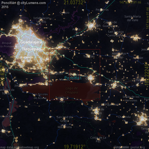
Analysis of Poncitlán night lights 2016
Square area 10x10 km:
 0%
0%90-99
0.76%80-89
1.7%70-79
3.22%60-69
3.03%50-59
3.03%40-49
2.46%30-39
3.41%20-29
0.95%10-19
0.38%0-9
81.06%Square area 50x50 km:
0.22%90-99
0.61%80-89
1.93%70-79
1.56%60-69
1.43%50-59
1.04%40-49
2.86%30-39
1.65%20-29
2.39%10-19
7.58%0-9
78.74%Clear (daylight) street map image can be seen on geolist.org.
Map coordinates:
21° 2' 14.4" North, 103° 37' 43.3" West
20° 22' 46.7" North, 102° 55' 32.1" West
19° 43' 8.8" North, 102° 13' 20.8" West
Some cities around Poncitlán sort by population:
• Ocotlán
16.1 km =10 mi,  99°
99°
• Jamay
24.7 km =15.3 mi,  112°
112°
• Tototlán
22.8 km =14.2 mi,  37°
37°
• Atotonilquillo
20.7 km =12.9 mi,  274°
274°
• Atequiza
22.4 km =13.9 mi, 272°
• Cuitzeo (La Estancia)
15.3 km =9.5 mi, 105°
• San Pedro Itzicán
7.5 km =4.7 mi,  203°
203°
• Mezcala
10.8 km =6.7 mi,  242°
242°
3992212 (p: 13,581)
Sources (retrieved 2019-11-25):
» Earth at Night: Flat Maps 2012, 2016