Cuitzeo (La Estancia) night lights from space
Night Light of Cuitzeo (La Estancia) (Jalisco) from space (Mexico) Src. Average luminocity for 10x10km area is 40.0511% and for 50x50km: 7.6322%.
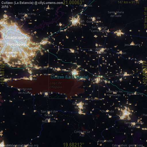
Analysis of Cuitzeo (La Estancia) night lights 2016
Square area 10x10 km:
 3.98%
3.98%90-99
8.33%80-89
9.09%70-79
5.11%60-69
3.79%50-59
1.33%40-49
10.61%30-39
3.6%20-29
7.58%10-19
35.8%0-9
10.8%Square area 50x50 km:
0.18%90-99
0.61%80-89
1.52%70-79
1.22%60-69
0.91%50-59
0.69%40-49
1.83%30-39
1.36%20-29
1.18%10-19
5.15%0-9
85.36%Clear (daylight) street map image can be seen on geolist.org.
Map coordinates:
21° 0' 2.3" North, 103° 29' 13.3" West
20° 20' 34" North, 102° 47' 2" West
19° 40' 55.6" North, 102° 4' 50.8" West
Some cities around Cuitzeo (La Estancia) sort by population:
• Ocotlán
1.8 km =1.1 mi,  37°
37°
• La Barca
25.6 km =15.9 mi,  103°
103°
• Jamay
9.7 km =6 mi,  124°
124°
• Poncitlán
15.3 km =9.5 mi,  285°
285°
• Tototlán
22.2 km =13.8 mi,  357°
357°
• Cojumatlán de Régules
25.9 km =16.1 mi,  195°
195°
• San Pedro Itzicán
18 km =11.2 mi,  260°
260°
• Mezcala
24.4 km =15.2 mi,  268°
268°
4012196 (p: 5,603)
Sources (retrieved 2019-11-25):
» Earth at Night: Flat Maps 2012, 2016