Tlayacapan night lights from space
Night Light of Tlayacapan (Morelos) from space (Mexico) Src. Average luminocity for 10x10km area is 42.1147% and for 50x50km: 32.6871%.
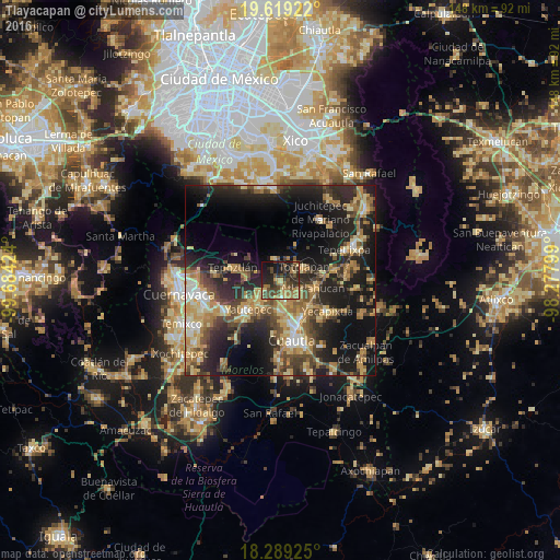
Analysis of Tlayacapan night lights 2016
Square area 10x10 km:
 0%
0%90-99
0.87%80-89
6.71%70-79
6.28%60-69
14.29%50-59
3.25%40-49
20.56%30-39
11.26%20-29
15.15%10-19
19.48%0-9
2.16%Square area 50x50 km:
1.63%90-99
3.07%80-89
6.12%70-79
6.01%60-69
6.6%50-59
3.96%40-49
7.43%30-39
5.64%20-29
12.56%10-19
20.51%0-9
26.48%Clear (daylight) street map image can be seen on geolist.org.
Map coordinates:
19° 37' 9.2" North, 99° 41' 3.3" West
18° 57' 20" North, 98° 58' 52" West
18° 17' 21.3" North, 98° 16' 40.8" West
Some cities around Tlayacapan sort by population:
• Yautepec
12.2 km =7.6 mi,  227°
227°
• Yecapixtla
14.6 km =9.1 mi,  123°
123°
• Tepoztlán
13 km =8.1 mi,  285°
285°
• Cocoyoc
7.9 km =4.9 mi,  180°
180°
• Atlatlahucan
9 km =5.6 mi,  105°
105°
• Oaxtepec
4.9 km =3 mi,  147°
147°
• Totolapan
7.1 km =4.4 mi,  62°
62°
• Los Arcos
8.8 km =5.5 mi,  210°
210°
3515343 (p: 7,989)
Sources (retrieved 2019-11-25):
» Earth at Night: Flat Maps 2012, 2016