Totolapan night lights from space
Night Light of Totolapan (Morelos) from space (Mexico) Src. Average luminocity for 10x10km area is 31.3074% and for 50x50km: 30.3948%.
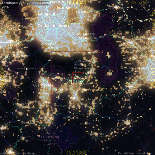
Analysis of Totolapan night lights 2016
Square area 10x10 km:
 0%
0%90-99
0.22%80-89
5.41%70-79
3.25%60-69
5.63%50-59
4.11%40-49
9.52%30-39
14.72%20-29
18.83%10-19
24.03%0-9
14.29%Square area 50x50 km:
1.21%90-99
2.44%80-89
5.52%70-79
5.37%60-69
6.57%50-59
3.83%40-49
7.42%30-39
5.29%20-29
11.7%10-19
19.75%0-9
30.91%Clear (daylight) street map image can be seen on geolist.org.
Map coordinates:
19° 38' 54.3" North, 99° 37' 25.9" West
18° 59' 5.5" North, 98° 55' 14.6" West
18° 19' 7.2" North, 98° 13' 3.4" West
Some cities around Totolapan sort by population:
• Yecapixtla
12.7 km =7.9 mi,  152°
152°
• Juchitepec
13.6 km =8.5 mi,  18°
18°
• Tepetlixpa
11.5 km =7.1 mi,  64°
64°
• Cocoyoc
12.9 km =8 mi,  209°
209°
• Tlayacapan
7.1 km =4.4 mi,  242°
242°
• Atlatlahucan
6.1 km =3.8 mi,  157°
157°
• Oaxtepec
8.3 km =5.2 mi, 206°
• San Matías Cuijingo
13.2 km =8.2 mi,  32°
32°
3515195 (p: 6,198)
Sources (retrieved 2019-11-25):
» Earth at Night: Flat Maps 2012, 2016