Oaxtepec night lights from space
Night Light of Oaxtepec (Morelos) from space (Mexico) Src. Average luminocity for 10x10km area is 60.6688% and for 50x50km: 30.4821%.
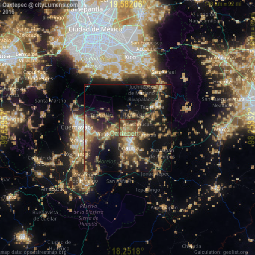
Analysis of Oaxtepec night lights 2016
Square area 10x10 km:
 0%
0%90-99
3.25%80-89
12.34%70-79
15.15%60-69
29%50-59
9.96%40-49
16.23%30-39
7.79%20-29
6.28%10-19
0%0-9
0%Square area 50x50 km:
1.21%90-99
2.21%80-89
5.67%70-79
5.59%60-69
6.47%50-59
3.84%40-49
7.53%30-39
5.73%20-29
10.36%10-19
21.5%0-9
29.9%Clear (daylight) street map image can be seen on geolist.org.
Map coordinates:
19° 34' 55.4" North, 99° 39' 34.5" West
18° 55' 5.7" North, 98° 57' 23.2" West
18° 15' 6.5" North, 98° 15' 12" West
Some cities around Oaxtepec sort by population:
• Cuautla
12.2 km =7.6 mi,  169°
169°
• Yautepec
12.3 km =7.6 mi,  250°
250°
• Yecapixtla
10.4 km =6.5 mi,  111°
111°
• Cocoyoc
4.6 km =2.9 mi,  215°
215°
• Tlayacapan
4.9 km =3 mi,  327°
327°
• Atlatlahucan
6.4 km =4 mi,  73°
73°
• Totolapan
8.3 km =5.2 mi,  26°
26°
• Los Arcos
7.9 km =4.9 mi,  244°
244°
3522505 (p: 6,939)
Sources (retrieved 2019-11-25):
» Earth at Night: Flat Maps 2012, 2016