Yecapixtla night lights from space
Night Light of Yecapixtla (Morelos) from space (Mexico) Src. Average luminocity for 10x10km area is 38.9091% and for 50x50km: 24.8289%.
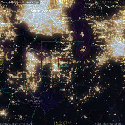
Analysis of Yecapixtla night lights 2016
Square area 10x10 km:
 0.65%
0.65%90-99
1.08%80-89
7.14%70-79
6.06%60-69
8.87%50-59
6.28%40-49
12.99%30-39
9.52%20-29
17.32%10-19
27.49%0-9
2.6%Square area 50x50 km:
0.76%90-99
1.51%80-89
4.33%70-79
4.54%60-69
5.8%50-59
3.17%40-49
5.94%30-39
4.57%20-29
7.81%10-19
18.57%0-9
42.98%Clear (daylight) street map image can be seen on geolist.org.
Map coordinates:
19° 32' 50.2" North, 99° 34' 5.3" West
18° 52' 60" North, 98° 51' 54" West
18° 13' 0.3" North, 98° 9' 42.8" West
Some cities around Yecapixtla sort by population:
• Cuautla
11 km =6.8 mi,  222°
222°
• Juan Morales
10 km =6.2 mi, 216°
• San Pedro Apatlaco
14.1 km =8.8 mi, 224°
• Cocoyoc
12.3 km =7.6 mi,  270°
270°
• Atlatlahucan
6.6 km =4.1 mi,  328°
328°
• Ecatzingo de Hidalgo
14.3 km =8.9 mi,  56°
56°
• Oaxtepec
10.4 km =6.5 mi,  291°
291°
• Totolapan
12.7 km =7.9 mi, 332°
3514278 (p: 16,811)
Sources (retrieved 2019-11-25):
» Earth at Night: Flat Maps 2012, 2016