Tepoztlán night lights from space
Night Light of Tepoztlán (Morelos) from space (Mexico) Src. Average luminocity for 10x10km area is 27.5303% and for 50x50km: 32.8806%.
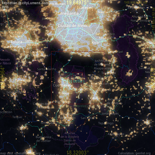
Analysis of Tepoztlán night lights 2016
Square area 10x10 km:
 0%
0%90-99
0%80-89
2.6%70-79
5.41%60-69
8.01%50-59
4.76%40-49
5.63%30-39
6.06%20-29
16.23%10-19
27.27%0-9
24.03%Square area 50x50 km:
2.25%90-99
4.52%80-89
6.94%70-79
6.03%60-69
5.98%50-59
3.71%40-49
7.13%30-39
4.78%20-29
10.16%10-19
13.13%0-9
35.37%Clear (daylight) street map image can be seen on geolist.org.
Map coordinates:
19° 38' 59.1" North, 99° 48' 13.1" West
18° 59' 10.4" North, 99° 6' 1.8" West
18° 19' 12.1" North, 98° 23' 50.6" West
Some cities around Tepoztlán sort by population:
• Cuernavaca
15.2 km =9.4 mi,  243°
243°
• Jiutepec
14.2 km =8.8 mi,  214°
214°
• Yautepec
12.1 km =7.5 mi,  163°
163°
• Progreso
13 km =8.1 mi,  204°
204°
• La Joya
10.9 km =6.8 mi,  192°
192°
• Tlayacapan
13 km =8.1 mi,  105°
105°
• Independencia
12.3 km =7.6 mi, 190°
• Los Arcos
13.6 km =8.5 mi,  143°
143°
3515811 (p: 14,130)
Sources (retrieved 2019-11-25):
» Earth at Night: Flat Maps 2012, 2016