Cocoyoc night lights from space
Night Light of Cocoyoc (Morelos) from space (Mexico) Src. Average luminocity for 10x10km area is 64.6991% and for 50x50km: 32.8278%.
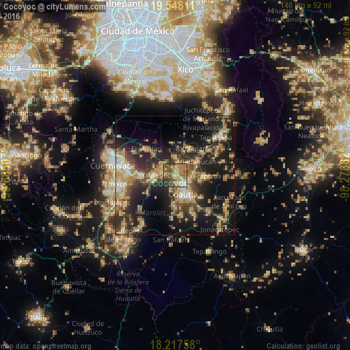
Analysis of Cocoyoc night lights 2016
Square area 10x10 km:
 2.16%
2.16%90-99
9.31%80-89
12.99%70-79
16.88%60-69
20.13%50-59
12.99%40-49
17.1%30-39
4.33%20-29
4.11%10-19
0%0-9
0%Square area 50x50 km:
1.55%90-99
2.93%80-89
6.36%70-79
6.38%60-69
6.55%50-59
3.85%40-49
7.88%30-39
5.95%20-29
10.85%10-19
20.45%0-9
27.24%Clear (daylight) street map image can be seen on geolist.org.
Map coordinates:
19° 32' 53.2" North, 99° 41' 6.3" West
18° 53' 3" North, 98° 58' 55" West
18° 13' 3.3" North, 98° 16' 43.8" West
Some cities around Cocoyoc sort by population:
• Cuautla
9.5 km =5.9 mi,  149°
149°
• Yautepec
9 km =5.6 mi,  268°
268°
• Juan Morales
10.3 km =6.4 mi,  142°
142°
• San Pedro Apatlaco
10.4 km =6.5 mi,  167°
167°
• Tlayacapan
7.9 km =4.9 mi,  0°
0°
• Atlatlahucan
10.4 km =6.5 mi,  57°
57°
• Oaxtepec
4.6 km =2.9 mi,  35°
35°
• Los Arcos
4.5 km =2.8 mi, 274°
3530492 (p: 9,663)
Sources (retrieved 2019-11-25):
» Earth at Night: Flat Maps 2012, 2016