Apaxco de Ocampo night lights from space
Night Light of Apaxco de Ocampo (México) from space (Mexico) Src. Average luminocity for 10x10km area is 47.1468% and for 50x50km: 38.6061%.
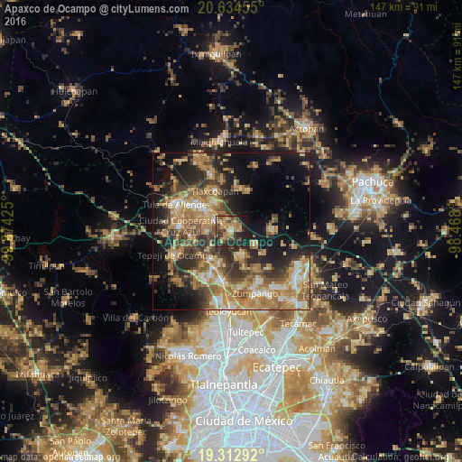
Analysis of Apaxco de Ocampo night lights 2016
Square area 10x10 km:
 1.98%
1.98%90-99
3.57%80-89
6.94%70-79
10.32%60-69
15.67%50-59
6.75%40-49
7.34%30-39
11.11%20-29
23.02%10-19
13.1%0-9
0.2%Square area 50x50 km:
2.84%90-99
4.01%80-89
5.64%70-79
7.83%60-69
11.41%50-59
5.74%40-49
6.73%30-39
6.95%20-29
9.88%10-19
14.86%0-9
24.11%Clear (daylight) street map image can be seen on geolist.org.
Map coordinates:
20° 38' 4.4" North, 99° 52' 27.3" West
19° 58' 30.4" North, 99° 10' 16" West
19° 18' 46.5" North, 98° 28' 4.8" West
Some cities around Apaxco de Ocampo sort by population:
• Tequixquiac
7.8 km =4.8 mi,  159°
159°
• Tlaxcoapan
13.9 km =8.6 mi,  338°
338°
• Santa María Ajoloapan
13.2 km =8.2 mi,  89°
89°
• Cardonal
11 km =6.8 mi,  325°
325°
• Atotonilco de Tula
6.1 km =3.8 mi,  306°
306°
• Ajacuba
13.9 km =8.6 mi,  21°
21°
• Tlapanaloya
8.9 km =5.5 mi,  119°
119°
• Atitalaquia
10.8 km =6.7 mi, 330°
3532803 (p: 13,836)
Sources (retrieved 2019-11-25):
» Earth at Night: Flat Maps 2012, 2016