Buenavista de Cuéllar night lights from space
Night Light of Buenavista de Cuéllar (Guerrero) from space (Mexico) Src. Average luminocity for 10x10km area is 6.3161% and for 50x50km: 10.6168%.
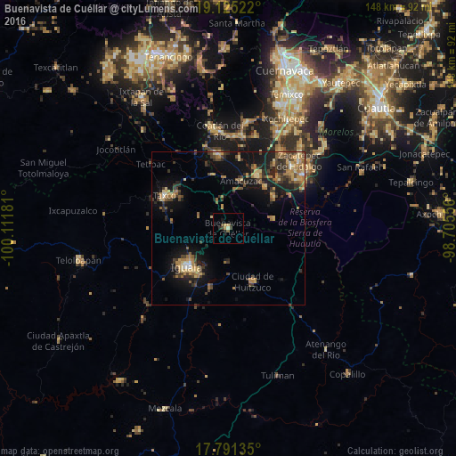
Analysis of Buenavista de Cuéllar night lights 2016
Square area 10x10 km:
 0%
0%90-99
0.83%80-89
0.21%70-79
2.27%60-69
0%50-59
0.83%40-49
2.07%30-39
0.62%20-29
2.48%10-19
1.45%0-9
89.26%Square area 50x50 km:
0.26%90-99
0.41%80-89
1.66%70-79
1.92%60-69
2.52%50-59
1.28%40-49
2.33%30-39
2.54%20-29
2.56%10-19
8.2%0-9
76.32%Clear (daylight) street map image can be seen on geolist.org.
Map coordinates:
19° 7' 30.8" North, 100° 6' 42.5" West
18° 27' 34.5" North, 99° 24' 31.2" West
17° 47' 28.9" North, 98° 42' 20" West
Some cities around Buenavista de Cuéllar sort by population:
• Iguala de la Independencia
18.9 km =11.7 mi,  227°
227°
• Puente de Ixtla
19.7 km =12.2 mi,  28°
28°
• Ciudad de Huitzuco
19.1 km =11.9 mi,  155°
155°
• Tehuixtla
18.3 km =11.4 mi,  52°
52°
• Tepecoacuilco de Trujano
20 km =12.4 mi,  197°
197°
• Tlamacazapa
10.5 km =6.5 mi,  292°
292°
• Amacuzac
16 km =9.9 mi,  14°
14°
• Acamixtla
20.3 km =12.6 mi,  305°
305°
3531972 (p: 7,131)
Sources (retrieved 2019-11-25):
» Earth at Night: Flat Maps 2012, 2016