Tihuatlan night lights from space
Night Light of Tihuatlan (Veracruz) from space (Mexico) Src. Average luminocity for 10x10km area is 8.2443% and for 50x50km: 12.789%.
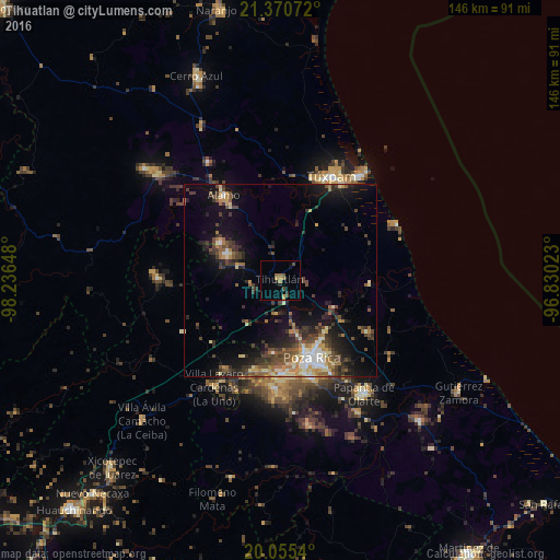
Analysis of Tihuatlan night lights 2016
Square area 10x10 km:
 0%
0%90-99
0%80-89
0.38%70-79
2.27%60-69
2.46%50-59
1.33%40-49
2.08%30-39
0.19%20-29
2.27%10-19
0.95%0-9
88.07%Square area 50x50 km:
0.9%90-99
1.33%80-89
1.72%70-79
1.32%60-69
1.94%50-59
1.89%40-49
3.22%30-39
3.07%20-29
3.66%10-19
8.2%0-9
72.75%Clear (daylight) street map image can be seen on geolist.org.
Map coordinates:
21° 22' 14.6" North, 98° 14' 11.3" West
20° 42' 52.2" North, 97° 32' 0.1" West
20° 3' 19.4" North, 96° 49' 48.8" West
Some cities around Tihuatlan sort by population:
• Poza Rica de Hidalgo
21.6 km =13.4 mi,  159°
159°
• Coatzintla
26.2 km =16.3 mi,  165°
165°
• Álamo
26.4 km =16.4 mi,  326°
326°
• Alto Lucero
28.2 km =17.5 mi,  19°
19°
• Plan de Ayala
19.5 km =12.1 mi, 160°
• Santiago de la Peña
28.9 km =18 mi,  27°
27°
• Totolapa
18.4 km =11.4 mi, 161°
• Venustiano Carranza
27 km =16.8 mi,  211°
211°
3515603 (p: 14,417)
Sources (retrieved 2019-11-25):
» Earth at Night: Flat Maps 2012, 2016