Totolapa night lights from space
Night Light of Totolapa (Veracruz) from space (Mexico) Src. Average luminocity for 10x10km area is 62.1951% and for 50x50km: 17.7667%.
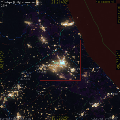
Analysis of Totolapa night lights 2016
Square area 10x10 km:
 14.02%
90-99
14.77%80-89
7.95%70-79
6.06%60-69
5.87%50-59
11.93%40-49
10.98%30-39
10.61%20-29
12.69%10-19
5.11%0-9
0%Square area 50x50 km:
0.9%90-99
1.66%80-89
2.5%70-79
1.95%60-69
3.07%50-59
2.91%40-49
4.86%30-39
4.94%20-29
5.83%10-19
10.83%0-9
60.54%Clear (daylight) street map image can be seen on geolist.org.
Map coordinates:
21° 12' 53.7" North, 98° 10' 46.2" West
20° 33' 28.8" North, 97° 28' 34.9" West
19° 53' 53.7" North, 96° 46' 23.7" West
Some cities around Totolapa sort by population:
• Poza Rica de Hidalgo
3.3 km =2.1 mi,  147°
147°
• Papantla de Olarte
20.1 km =12.5 mi,  128°
128°
• Coatzintla
7.9 km =4.9 mi,  173°
173°
• Tihuatlan
18.4 km =11.4 mi,  341°
341°
• Villa Lázaro Cárdenas
25.6 km =15.9 mi,  245°
245°
• Plan de Ayala
1.1 km =0.7 mi, 152°
• Venustiano Carranza
20.8 km =12.9 mi, 254°
• Agua Dulce
28.9 km =18 mi,  138°
138°
3824523 (p: 8,060)
Sources (retrieved 2019-11-25):
» Earth at Night: Flat Maps 2012, 2016