Santiago de la Peña night lights from space
Night Light of Santiago de la Peña (Veracruz) from space (Mexico) Src. Average luminocity for 10x10km area is 42.6766% and for 50x50km: 4.2311%.
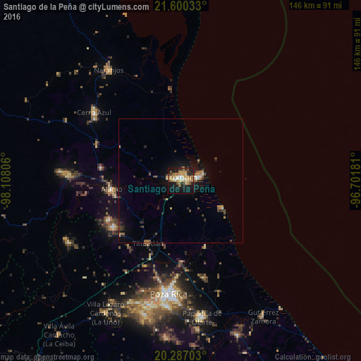
Analysis of Santiago de la Peña night lights 2016
Square area 10x10 km:
 2.18%
2.18%90-99
5.16%80-89
6.55%70-79
15.28%60-69
7.74%50-59
4.76%40-49
3.37%30-39
5.16%20-29
10.32%10-19
33.53%0-9
5.95%Square area 50x50 km:
0.18%90-99
0.34%80-89
0.44%70-79
1%60-69
0.68%50-59
0.36%40-49
0.73%30-39
0.66%20-29
1%10-19
3.79%0-9
90.82%Clear (daylight) street map image can be seen on geolist.org.
Map coordinates:
21° 36' 1.2" North, 98° 6' 29" West
20° 56' 42.4" North, 97° 24' 17.7" West
20° 17' 13.3" North, 96° 42' 6.5" West
Some cities around Santiago de la Peña sort by population:
• Túxpam de Rodríguez Cano
1.4 km =0.9 mi,  347°
347°
• Álamo
28.4 km =17.6 mi,  262°
262°
• Cerro Azul
44.4 km =27.6 mi,  308°
308°
• Alto Lucero
4 km =2.5 mi,  283°
283°
• Tihuatlan
28.9 km =18 mi,  207°
207°
• Plan de Ayala
44.6 km =27.7 mi,  188°
188°
• Totolapa
43.7 km =27.2 mi, 189°
• Tamiahua
37.3 km =23.2 mi, 353°
3516956 (p: 8,657)
Sources (retrieved 2019-11-25):
» Earth at Night: Flat Maps 2012, 2016