La Joya night lights from space
Night Light of La Joya (Morelos) from space (Mexico) Src. Average luminocity for 10x10km area is 57.1082% and for 50x50km: 32.9724%.
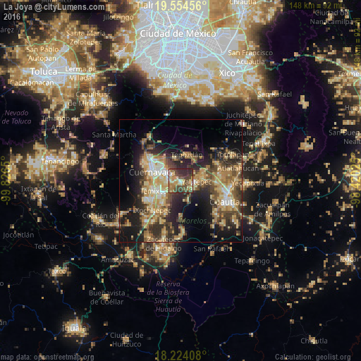
Analysis of La Joya night lights 2016
Square area 10x10 km:
 3.03%
3.03%90-99
4.55%80-89
15.37%70-79
10.61%60-69
11.69%50-59
3.68%40-49
27.06%30-39
9.31%20-29
14.72%10-19
0%0-9
0%Square area 50x50 km:
1.8%90-99
3.93%80-89
7.06%70-79
6.39%60-69
6.25%50-59
3.76%40-49
7.74%30-39
5.59%20-29
9.61%10-19
14%0-9
33.87%Clear (daylight) street map image can be seen on geolist.org.
Map coordinates:
19° 33' 16.4" North, 99° 49' 35.4" West
18° 53' 26.3" North, 99° 7' 24.1" West
18° 13' 26.7" North, 98° 25' 12.9" West
Some cities around La Joya sort by population:
• Jiutepec
5.8 km =3.6 mi,  259°
259°
• Emiliano Zapata
8.5 km =5.3 mi,  229°
229°
• Yautepec
6 km =3.7 mi,  99°
99°
• Tres de Mayo
9.3 km =5.8 mi,  254°
254°
• Progreso
3.3 km =2.1 mi, 249°
• Independencia
1.5 km =0.9 mi,  175°
175°
• Los Arcos
10.4 km =6.5 mi,  92°
92°
• Calera Chica
7.1 km =4.4 mi,  239°
239°
11228715 (p: 13,715)
Sources (retrieved 2019-11-25):
» Earth at Night: Flat Maps 2012, 2016