San Juan Tuxco night lights from space
Night Light of San Juan Tuxco (Puebla) from space (Mexico) Src. Average luminocity for 10x10km area is 66.8377% and for 50x50km: 34.4254%.
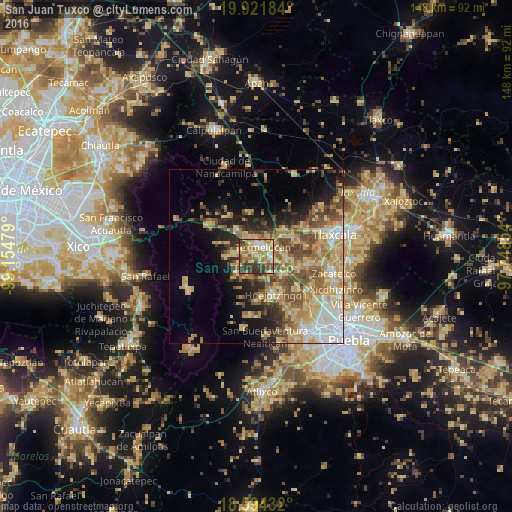
Analysis of San Juan Tuxco night lights 2016
Square area 10x10 km:
 5.19%
5.19%90-99
12.55%80-89
19.26%70-79
11.69%60-69
14.72%50-59
8.66%40-49
10.39%30-39
16.45%20-29
1.08%10-19
0%0-9
0%Square area 50x50 km:
3.85%90-99
3.7%80-89
9.1%70-79
6.59%60-69
5.79%50-59
5.36%40-49
6.26%30-39
3.9%20-29
5.07%10-19
8.95%0-9
41.42%Clear (daylight) street map image can be seen on geolist.org.
Map coordinates:
19° 55' 18.6" North, 99° 9' 17.2" West
19° 15' 33.9" North, 98° 27' 6" West
18° 35' 39.6" North, 97° 44' 54.7" West
Some cities around San Juan Tuxco sort by population:
• San Martin Texmelucan de Labastida
3.1 km =1.9 mi,  25°
25°
• Moyotzingo
5.1 km =3.2 mi,  104°
104°
• San Rafael Tlanalapan
4 km =2.5 mi,  334°
334°
• San Lucas el Grande
5.9 km =3.7 mi, 331°
• Tepetitla
7.9 km =4.9 mi,  85°
85°
• San Lorenzo Chiautzingo
6.3 km =3.9 mi,  195°
195°
• Teotlaltzingo
6.1 km =3.8 mi,  238°
238°
• Villa Alta
6.5 km =4 mi,  55°
55°
9082399 (p: 6,170)
Sources (retrieved 2019-11-25):
» Earth at Night: Flat Maps 2012, 2016