Teolocholco night lights from space
Night Light of Teolocholco (Tlaxcala) from space (Mexico) Src. Average luminocity for 10x10km area is 73.0195% and for 50x50km: 51.6468%.
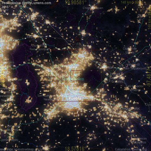
Analysis of Teolocholco night lights 2016
Square area 10x10 km:
 1.52%
1.52%90-99
10.17%80-89
34.2%70-79
26.41%60-69
7.79%50-59
4.33%40-49
8.01%30-39
5.19%20-29
2.38%10-19
0%0-9
0%Square area 50x50 km:
8.04%90-99
7.09%80-89
14.08%70-79
9.99%60-69
7.6%50-59
7.04%40-49
8.18%30-39
4.64%20-29
6.04%10-19
9.46%0-9
17.86%Clear (daylight) street map image can be seen on geolist.org.
Map coordinates:
19° 54' 20.9" North, 98° 53' 38.3" West
19° 14' 36" North, 98° 11' 27" West
18° 34' 41.4" North, 97° 29' 15.8" West
Some cities around Teolocholco sort by population:
• Zacatelco
6 km =3.7 mi,  239°
239°
• La Magdalena Tlaltelulco
4.4 km =2.7 mi,  352°
352°
• Acuitlapilco
5.7 km =3.5 mi,  305°
305°
• San Francisco Tetlanohcan
3.4 km =2.1 mi,  56°
56°
• Tetlanohcán
3.4 km =2.1 mi, 55°
• Santa Catarina Ayometla
5.5 km =3.4 mi,  205°
205°
• San Juan Huactzinco
6.6 km =4.1 mi,  260°
260°
• San Lorenzo Axocomanitla
6.4 km =4 mi,  250°
250°
3518475 (p: 16,240)
Sources (retrieved 2019-11-25):
» Earth at Night: Flat Maps 2012, 2016