Tetlanohcán night lights from space
Night Light of Tetlanohcán (Tlaxcala) from space (Mexico) Src. Average luminocity for 10x10km area is 62.0152% and for 50x50km: 49.1617%.
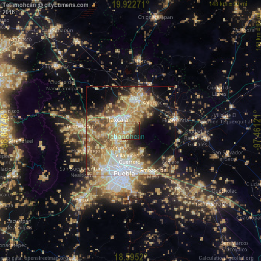
Analysis of Tetlanohcán night lights 2016
Square area 10x10 km:
 1.3%
1.3%90-99
6.71%80-89
30.09%70-79
14.07%60-69
7.58%50-59
6.71%40-49
9.74%30-39
7.14%20-29
8.01%10-19
8.66%0-9
0%Square area 50x50 km:
7.19%90-99
6.49%80-89
13.53%70-79
9.71%60-69
7.27%50-59
6.48%40-49
8.06%30-39
4.32%20-29
6.03%10-19
10.52%0-9
20.4%Clear (daylight) street map image can be seen on geolist.org.
Map coordinates:
19° 55' 21.8" North, 98° 52' 2.9" West
19° 15' 37.1" North, 98° 9' 51.6" West
18° 35' 42.7" North, 97° 27' 40.4" West
Some cities around Tetlanohcán sort by population:
• Tlaxcala
7.5 km =4.7 mi,  330°
330°
• Santa Ana Chiautempan
5.7 km =3.5 mi, 334°
• Contla
7.7 km =4.8 mi,  358°
358°
• La Magdalena Tlaltelulco
4.2 km =2.6 mi,  306°
306°
• Teolocholco
3.4 km =2.1 mi,  235°
235°
• Acuitlapilco
7.6 km =4.7 mi,  280°
280°
• San Francisco Tetlanohcan
0.1 km =0.1 mi,  99°
99°
• Santa Catarina Ayometla
8.6 km =5.3 mi,  216°
216°
3815359 (p: 9,832)
Sources (retrieved 2019-11-25):
» Earth at Night: Flat Maps 2012, 2016