San Juan Huactzinco night lights from space
Night Light of San Juan Huactzinco (Tlaxcala) from space (Mexico) Src. Average luminocity for 10x10km area is 75.6429% and for 50x50km: 54.024%.
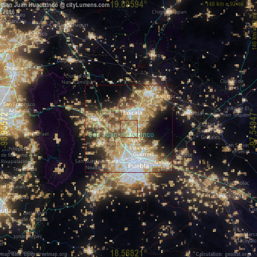
Analysis of San Juan Huactzinco night lights 2016
Square area 10x10 km:
 4.11%
4.11%90-99
8.44%80-89
30.95%70-79
26.62%60-69
11.9%50-59
14.29%40-49
3.68%30-39
0%20-29
0%10-19
0%0-9
0%Square area 50x50 km:
8.55%90-99
7.4%80-89
14.82%70-79
10.23%60-69
8.23%50-59
7.3%40-49
8.18%30-39
5.5%20-29
6.37%10-19
8.85%0-9
14.57%Clear (daylight) street map image can be seen on geolist.org.
Map coordinates:
19° 53' 45.4" North, 98° 57' 20.6" West
19° 14' 0.3" North, 98° 15' 9.3" West
18° 34' 5.6" North, 97° 32' 58.1" West
Some cities around San Juan Huactzinco sort by population:
• Zacatelco
2.4 km =1.5 mi,  145°
145°
• La Magdalena Tlaltelulco
8.1 km =5 mi,  47°
47°
• Teolocholco
6.6 km =4.1 mi,  80°
80°
• Acuitlapilco
4.8 km =3 mi,  22°
22°
• Xicohtzinco
6.9 km =4.3 mi,  163°
163°
• Santa Catarina Ayometla
5.7 km =3.5 mi,  133°
133°
• San Damián Texoloc
6.1 km =3.8 mi,  325°
325°
• San Lorenzo Axocomanitla
1.1 km =0.7 mi, 158°
3815391 (p: 6,687)
Sources (retrieved 2019-11-25):
» Earth at Night: Flat Maps 2012, 2016