San Lorenzo Axocomanitla night lights from space
Night Light of San Lorenzo Axocomanitla (Tlaxcala) from space (Mexico) Src. Average luminocity for 10x10km area is 76.1277% and for 50x50km: 54.5734%.
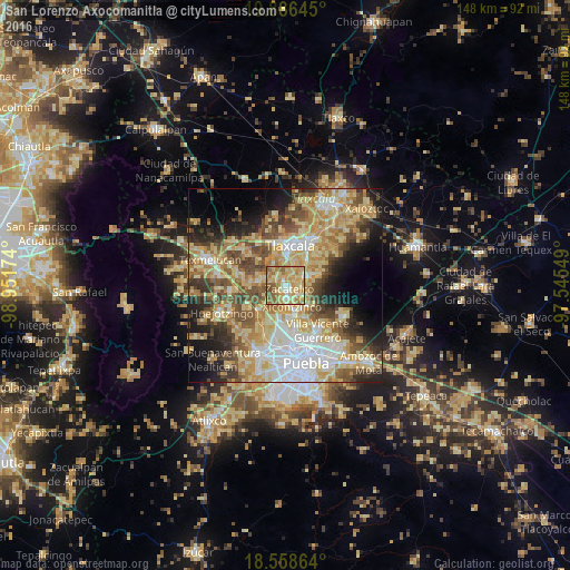
Analysis of San Lorenzo Axocomanitla night lights 2016
Square area 10x10 km:
 4.11%
4.11%90-99
9.74%80-89
30.52%70-79
26.41%60-69
11.9%50-59
14.29%40-49
3.03%30-39
0%20-29
0%10-19
0%0-9
0%Square area 50x50 km:
8.92%90-99
7.55%80-89
14.94%70-79
10.24%60-69
8.1%50-59
7.36%40-49
8.15%30-39
5.5%20-29
6.41%10-19
8.87%0-9
13.95%Clear (daylight) street map image can be seen on geolist.org.
Map coordinates:
19° 53' 11.2" North, 98° 57' 6.3" West
19° 13' 26" North, 98° 14' 55" West
18° 33' 31.1" North, 97° 32' 43.8" West
Some cities around San Lorenzo Axocomanitla sort by population:
• Zacatelco
1.3 km =0.8 mi,  133°
133°
• Papalotla
7.7 km =4.8 mi,  142°
142°
• Teolocholco
6.4 km =4 mi,  70°
70°
• Acuitlapilco
5.7 km =3.5 mi,  14°
14°
• Xicohtzinco
5.8 km =3.6 mi,  164°
164°
• Santa Catarina Ayometla
4.6 km =2.9 mi, 127°
• San Juan Huactzinco
1.1 km =0.7 mi,  338°
338°
• San Damián Texoloc
7.2 km =4.5 mi,  327°
327°
8858268 (p: 5,007)
Sources (retrieved 2019-11-25):
» Earth at Night: Flat Maps 2012, 2016