Delta night lights from space
Night Light of Delta (Baja California) from space (Mexico) Src. Average luminocity for 10x10km area is 8.9505% and for 50x50km: 6.5066%.
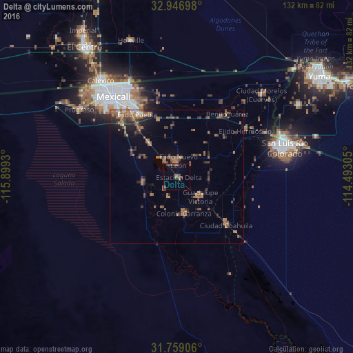
Analysis of Delta night lights 2016
Square area 10x10 km:
 0%
0%90-99
0%80-89
0%70-79
0.18%60-69
1.83%50-59
3.66%40-49
4.21%30-39
2.38%20-29
0%10-19
0.73%0-9
87%Square area 50x50 km:
0.18%90-99
0.2%80-89
0.07%70-79
0.25%60-69
2.93%50-59
2.04%40-49
1.42%30-39
1.23%20-29
1.6%10-19
2.24%0-9
87.84%Clear (daylight) street map image can be seen on geolist.org.
Map coordinates:
32° 56' 49.1" North, 115° 53' 57.5" West
32° 21' 17.9" North, 115° 11' 46.2" West
31° 45' 32.6" North, 114° 29' 35" West
Some cities around Delta sort by population:
• Guadalupe Victoria
11.2 km =7 mi,  130°
130°
• Puebla
27.8 km =17.3 mi,  327°
327°
• Doctor Alberto Oviedo Mota
14.4 km =8.9 mi,  169°
169°
• Estación Coahuila
25.8 km =16 mi, 134°
• Colonia Venustiano Carranza
13.4 km =8.3 mi, 168°
• Ciudad Coahuila (Kilómetro Cincuenta y Siete)
25.4 km =15.8 mi, 134°
• Tecolots
30.9 km =19.2 mi,  40°
40°
• Hermosillo
31 km =19.3 mi,  55°
55°
3979510 (p: 5,180)
Sources (retrieved 2019-11-25):
» Earth at Night: Flat Maps 2012, 2016