Tecolotlán night lights from space
Night Light of Tecolotlán (Jalisco) from space (Mexico) Src. Average luminocity for 10x10km area is 4.9643% and for 50x50km: 1.1019%.
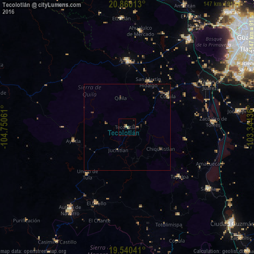
Analysis of Tecolotlán night lights 2016
Square area 10x10 km:
 0%
0%90-99
0%80-89
1.79%70-79
1.39%60-69
0%50-59
0.2%40-49
1.59%30-39
0.6%20-29
2.38%10-19
0%0-9
92.06%Square area 50x50 km:
0%90-99
0.01%80-89
0.22%70-79
0.16%60-69
0.16%50-59
0.25%40-49
0.41%30-39
0.2%20-29
0.25%10-19
0.13%0-9
98.21%Clear (daylight) street map image can be seen on geolist.org.
Map coordinates:
20° 51' 36.5" North, 104° 45' 2.2" West
20° 12' 6" North, 104° 2' 50.9" West
19° 32' 25.5" North, 103° 20' 39.7" West
Some cities around Tecolotlán sort by population:
• Ameca
38.3 km =23.8 mi,  0°
0°
• Cocula
29.7 km =18.5 mi,  52°
52°
• Unión de Tula
35.7 km =22.2 mi,  220°
220°
• San Martín Hidalgo
28.8 km =17.9 mi,  25°
25°
• Villa Corona
46.5 km =28.9 mi,  59°
59°
• Ayutla
31.9 km =19.8 mi,  255°
255°
• Tapalpa
41.4 km =25.7 mi,  133°
133°
• Atemajac de Brizuela
34.3 km =21.3 mi,  102°
102°
3982217 (p: 9,189)
Sources (retrieved 2019-11-25):
» Earth at Night: Flat Maps 2012, 2016