Villa Corona night lights from space
Night Light of Villa Corona (Jalisco) from space (Mexico) Src. Average luminocity for 10x10km area is 11.3674% and for 50x50km: 12.895%.
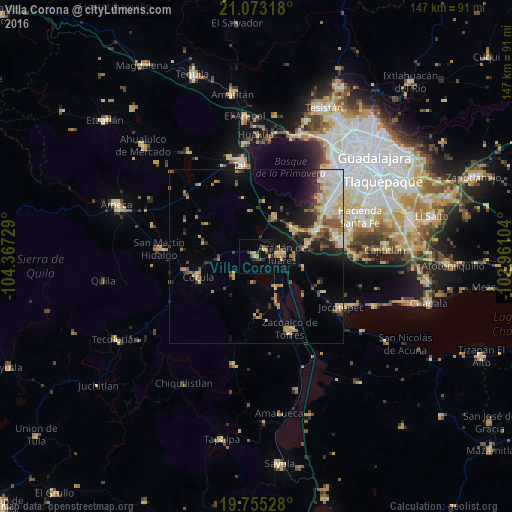
Analysis of Villa Corona night lights 2016
Square area 10x10 km:
 0%
0%90-99
0%80-89
3.03%70-79
1.7%60-69
1.33%50-59
0.19%40-49
2.84%30-39
2.27%20-29
3.79%10-19
4.36%0-9
80.49%Square area 50x50 km:
1.6%90-99
1.8%80-89
2.49%70-79
2.08%60-69
1.63%50-59
1.36%40-49
1.69%30-39
1.56%20-29
2.69%10-19
5.15%0-9
77.95%Clear (daylight) street map image can be seen on geolist.org.
Map coordinates:
21° 4' 23.4" North, 104° 22' 2.2" West
20° 24' 56.3" North, 103° 39' 51" West
19° 45' 19" North, 102° 57' 39.7" West
Some cities around Villa Corona sort by population:
• Nicolás R Casillas
25.2 km =15.7 mi,  54°
54°
• Tlajomulco de Zúñiga
23.6 km =14.7 mi,  73°
73°
• Zacoalco de Torres
23.1 km =14.4 mi,  154°
154°
• Cocula
17.4 km =10.8 mi,  251°
251°
• Lomas de San Agustín
23.9 km =14.9 mi,  58°
58°
• Santa Cruz de las Flores
18.3 km =11.4 mi, 66°
• Acatlán de Juárez
7.7 km =4.8 mi,  84°
84°
• Bellavista
3.5 km =2.2 mi, 53°
3980198 (p: 7,603)
Sources (retrieved 2019-11-25):
» Earth at Night: Flat Maps 2012, 2016