Atemajac de Brizuela night lights from space
Night Light of Atemajac de Brizuela (Jalisco) from space (Mexico) Src. Average luminocity for 10x10km area is 3.5% and for 50x50km: 2.5391%.
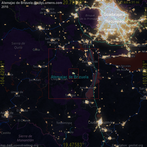
Analysis of Atemajac de Brizuela night lights 2016
Square area 10x10 km:
 0%
0%90-99
0.2%80-89
1.39%70-79
0.6%60-69
0.99%50-59
0%40-49
0.4%30-39
0.4%20-29
0.79%10-19
0%0-9
95.24%Square area 50x50 km:
0%90-99
0.05%80-89
0.4%70-79
0.63%60-69
0.56%50-59
0.49%40-49
0.44%30-39
0.35%20-29
0.42%10-19
0.35%0-9
96.31%Clear (daylight) street map image can be seen on geolist.org.
Map coordinates:
20° 47' 45.9" North, 104° 25' 44.4" West
20° 8' 14.5" North, 103° 43' 33.2" West
19° 28' 33" North, 103° 1' 21.9" West
Some cities around Atemajac de Brizuela sort by population:
• Sayula
31.3 km =19.4 mi,  155°
155°
• Zacoalco de Torres
19.3 km =12 mi,  58°
58°
• Cocula
27.2 km =16.9 mi,  338°
338°
• Tecolotlán
34.3 km =21.3 mi,  282°
282°
• Villa Corona
31.6 km =19.6 mi,  11°
11°
• Bellavista
34.3 km =21.3 mi,  15°
15°
• Tapalpa
21.6 km =13.4 mi,  189°
189°
• Atoyac
26.1 km =16.2 mi,  122°
122°
4018043 (p: 5,457)
Sources (retrieved 2019-11-25):
» Earth at Night: Flat Maps 2012, 2016