Cocula night lights from space
Night Light of Cocula (Jalisco) from space (Mexico) Src. Average luminocity for 10x10km area is 12.5095% and for 50x50km: 4.927%.
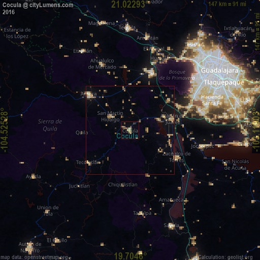
Analysis of Cocula night lights 2016
Square area 10x10 km:
 0%
0%90-99
0.19%80-89
2.84%70-79
2.46%60-69
3.03%50-59
2.27%40-49
2.65%30-39
1.89%20-29
1.33%10-19
0%0-9
83.33%Square area 50x50 km:
0.04%90-99
0.06%80-89
1.15%70-79
1%60-69
0.92%50-59
0.53%40-49
0.88%30-39
0.75%20-29
1.01%10-19
1.28%0-9
92.39%Clear (daylight) street map image can be seen on geolist.org.
Map coordinates:
21° 1' 22.5" North, 104° 31' 31" West
20° 21' 54.6" North, 103° 49' 19.7" West
19° 42' 16.6" North, 103° 7' 8.5" West
Some cities around Cocula sort by population:
• Ameca
30.7 km =19.1 mi,  310°
310°
• Zacoalco de Torres
30.5 km =19 mi,  119°
119°
• Acatlán de Juárez
25 km =15.5 mi,  75°
75°
• Tecolotlán
29.7 km =18.5 mi,  232°
232°
• San Martín Hidalgo
13.6 km =8.5 mi, 305°
• Villa Corona
17.4 km =10.8 mi,  71°
71°
• Bellavista
20.7 km =12.9 mi, 68°
• Atemajac de Brizuela
27.2 km =16.9 mi,  158°
158°
4013579 (p: 14,548)
Sources (retrieved 2019-11-25):
» Earth at Night: Flat Maps 2012, 2016