San Martín Hidalgo night lights from space
Night Light of San Martín Hidalgo (Jalisco) from space (Mexico) Src. Average luminocity for 10x10km area is 7.1042% and for 50x50km: 3.6316%.
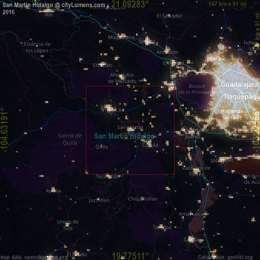
Analysis of San Martín Hidalgo night lights 2016
Square area 10x10 km:
 0%
0%90-99
0.19%80-89
1.33%70-79
1.7%60-69
2.84%50-59
0%40-49
1.33%30-39
0.95%20-29
0%10-19
0.76%0-9
90.91%Square area 50x50 km:
0.1%90-99
0.11%80-89
0.7%70-79
0.66%60-69
0.66%50-59
0.42%40-49
0.89%30-39
0.49%20-29
0.59%10-19
0.86%0-9
94.49%Clear (daylight) street map image can be seen on geolist.org.
Map coordinates:
21° 5' 34.2" North, 104° 37' 54.9" West
20° 26' 7.4" North, 103° 55' 43.6" West
19° 46' 30.4" North, 103° 13' 32.4" West
Some cities around San Martín Hidalgo sort by population:
• Ameca
17.3 km =10.7 mi,  315°
315°
• Tala
33.9 km =21.1 mi,  44°
44°
• Ahualulco de Mercado
30 km =18.6 mi,  350°
350°
• Cocula
13.6 km =8.5 mi,  125°
125°
• Tecolotlán
28.8 km =17.9 mi,  205°
205°
• Villa Corona
27.7 km =17.2 mi,  94°
94°
• Bellavista
30.4 km =18.9 mi, 90°
• El Refugio
32.8 km =20.4 mi, 36°
3985504 (p: 8,092)
Sources (retrieved 2019-11-25):
» Earth at Night: Flat Maps 2012, 2016