Tapalpa night lights from space
Night Light of Tapalpa (Jalisco) from space (Mexico) Src. Average luminocity for 10x10km area is 5.881% and for 50x50km: 1.8156%.
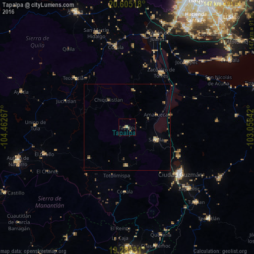
Analysis of Tapalpa night lights 2016
Square area 10x10 km:
 0%
0%90-99
0.65%80-89
1.08%70-79
0.43%60-69
2.38%50-59
1.52%40-49
0.87%30-39
0.87%20-29
0%10-19
0.43%0-9
91.77%Square area 50x50 km:
0.02%90-99
0.08%80-89
0.47%70-79
0.24%60-69
0.35%50-59
0.39%40-49
0.39%30-39
0.3%20-29
0.21%10-19
0.16%0-9
97.38%Clear (daylight) street map image can be seen on geolist.org.
Map coordinates:
20° 36' 18.6" North, 104° 27' 45.6" West
19° 56' 44.3" North, 103° 45' 34.3" West
19° 16' 59.9" North, 103° 3' 23.1" West
Some cities around Tapalpa sort by population:
• Sayula
18.1 km =11.2 mi,  112°
112°
• Zacoalco de Torres
37.2 km =23.1 mi,  32°
32°
• San Gabriel
32.1 km =19.9 mi,  231°
231°
• Usmajac
24.2 km =15 mi, 109°
• San Sebastián del Sur
34.4 km =21.4 mi,  119°
119°
• Atemajac de Brizuela
21.6 km =13.4 mi,  9°
9°
• San Andrés Ixtlán
33.4 km =20.8 mi, 114°
• Atoyac
26.4 km =16.4 mi,  74°
74°
3982461 (p: 5,782)
Sources (retrieved 2019-11-25):
» Earth at Night: Flat Maps 2012, 2016