Copainalá night lights from space
Night Light of Copainalá (Chiapas) from space (Mexico) Src. Average luminocity for 10x10km area is 3.1299% and for 50x50km: 1.5662%.
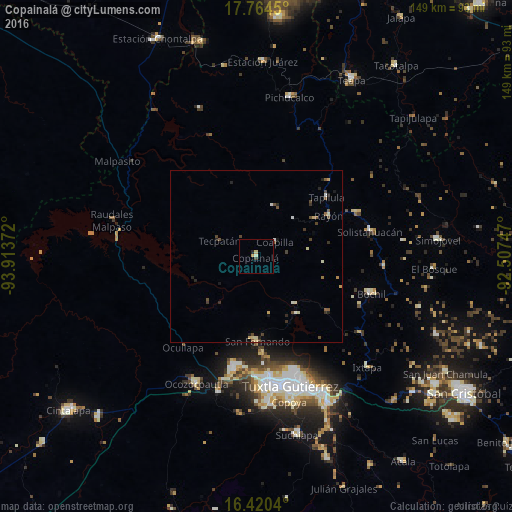
Analysis of Copainalá night lights 2016
Square area 10x10 km:
 0%
0%90-99
0.87%80-89
0.87%70-79
0.87%60-69
0%50-59
0%40-49
0%30-39
0.87%20-29
0.87%10-19
0%0-9
95.67%Square area 50x50 km:
0.03%90-99
0.3%80-89
0.27%70-79
0.14%60-69
0.06%50-59
0.25%40-49
0.55%30-39
0.26%20-29
0.42%10-19
0.19%0-9
97.53%Clear (daylight) street map image can be seen on geolist.org.
Map coordinates:
17° 45' 52.2" North, 93° 54' 49.4" West
17° 5' 37.2" North, 93° 12' 38.1" West
16° 25' 13.4" North, 92° 30' 26.9" West
Some cities around Copainalá sort by population:
• Tuxtla
38.6 km =24 mi,  164°
164°
• Berriozábal
33.5 km =20.8 mi,  191°
191°
• Bochil
35.5 km =22.1 mi,  107°
107°
• Pueblo Nuevo
33.8 km =21 mi,  77°
77°
• San Fernando
24.7 km =15.3 mi,  179°
179°
• Tapilula
26.9 km =16.7 mi,  49°
49°
• Rayón
24.3 km =15.1 mi,  60°
60°
• Rincón Chamula
31.5 km =19.6 mi,  66°
66°
3530267 (p: 6,550)
Sources (retrieved 2019-11-25):
» Earth at Night: Flat Maps 2012, 2016