Simojovel de Allende night lights from space
Night Light of Simojovel de Allende (Chiapas) from space (Mexico) Src. Average luminocity for 10x10km area is 9.9481% and for 50x50km: 4.2%.
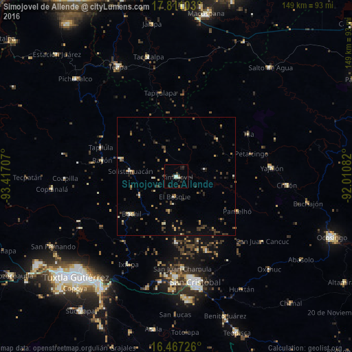
Analysis of Simojovel de Allende night lights 2016
Square area 10x10 km:
 0%
0%90-99
4.33%80-89
0%70-79
0%60-69
0%50-59
0.87%40-49
3.9%30-39
0%20-29
3.46%10-19
2.6%0-9
84.85%Square area 50x50 km:
0.04%90-99
0.56%80-89
0.52%70-79
0.44%60-69
0.45%50-59
0.44%40-49
1.01%30-39
1.05%20-29
1.43%10-19
1.23%0-9
92.83%Clear (daylight) street map image can be seen on geolist.org.
Map coordinates:
17° 48' 39.7" North, 93° 25' 1.5" West
17° 8' 25.3" North, 92° 42' 50.2" West
16° 28' 2.1" North, 92° 0' 39" West
Some cities around Simojovel de Allende sort by population:
• Bochil
24.8 km =15.4 mi,  229°
229°
• Pueblo Nuevo
19.9 km =12.4 mi,  276°
276°
• Pantelhó
29.8 km =18.5 mi,  120°
120°
• Petalcingo
33.2 km =20.6 mi,  73°
73°
• Rayón
32.3 km =20.1 mi, 282°
• Rincón Chamula
25 km =15.5 mi,  287°
287°
• Chilón
33.2 km =20.6 mi, 71°
• El Bosque
8.7 km =5.4 mi,  185°
185°
3516651 (p: 10,762)
Sources (retrieved 2019-11-25):
» Earth at Night: Flat Maps 2012, 2016