Suchiapa night lights from space
Night Light of Suchiapa (Chiapas) from space (Mexico) Src. Average luminocity for 10x10km area is 18.658% and for 50x50km: 16.96%.
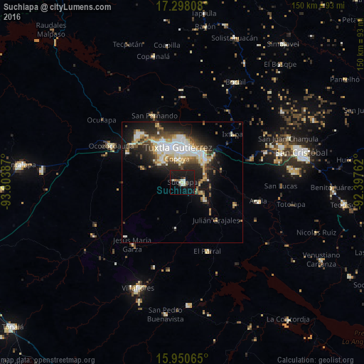
Analysis of Suchiapa night lights 2016
Square area 10x10 km:
 0.65%
0.65%90-99
4.98%80-89
1.3%70-79
0%60-69
0.87%50-59
1.73%40-49
3.25%30-39
1.95%20-29
1.3%10-19
44.37%0-9
39.61%Square area 50x50 km:
2.53%90-99
4.31%80-89
2.23%70-79
1.79%60-69
1.14%50-59
1.86%40-49
2.66%30-39
2.31%20-29
4.74%10-19
10.14%0-9
66.28%Clear (daylight) street map image can be seen on geolist.org.
Map coordinates:
17° 17' 53.1" North, 93° 48' 13.9" West
16° 37' 32" North, 93° 6' 2.7" West
15° 57' 2.3" North, 92° 23' 51.4" West
Some cities around Suchiapa sort by population:
• Tuxtla
15 km =9.3 mi,  354°
354°
• Chiapa de Corzo
13.2 km =8.2 mi,  46°
46°
• Berriozábal
26.5 km =16.5 mi,  316°
316°
• Acala
32.5 km =20.2 mi,  103°
103°
• El Parral
30.1 km =18.7 mi,  160°
160°
• San Fernando
29.6 km =18.4 mi,  337°
337°
• Copoya
9.8 km =6.1 mi, 347°
• Ixtapa
28.7 km =17.8 mi, 46°
3516499 (p: 16,637)
Sources (retrieved 2019-11-25):
» Earth at Night: Flat Maps 2012, 2016