San Fernando night lights from space
Night Light of San Fernando (Chiapas) from space (Mexico) Src. Average luminocity for 10x10km area is 16.1234% and for 50x50km: 15.8007%.
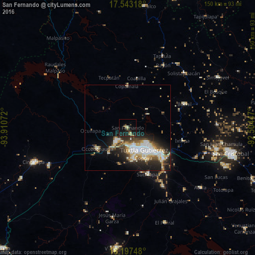
Analysis of San Fernando night lights 2016
Square area 10x10 km:
 0%
0%90-99
0%80-89
4.98%70-79
1.52%60-69
1.3%50-59
1.73%40-49
4.55%30-39
1.08%20-29
5.63%10-19
25.54%0-9
53.68%Square area 50x50 km:
2.5%90-99
4.03%80-89
2.3%70-79
1.56%60-69
0.87%50-59
1.63%40-49
2.68%30-39
2.23%20-29
4.63%10-19
7.94%0-9
69.63%Clear (daylight) street map image can be seen on geolist.org.
Map coordinates:
17° 32' 35.4" North, 93° 54' 38.6" West
16° 52' 17.5" North, 93° 12' 27.3" West
16° 11' 50.9" North, 92° 30' 16.1" West
Some cities around San Fernando sort by population:
• Tuxtla
16 km =9.9 mi,  141°
141°
• Chiapa de Corzo
27.7 km =17.2 mi,  131°
131°
• Ocozocoautla de Espinosa
21.5 km =13.4 mi,  235°
235°
• Berriozábal
10.6 km =6.6 mi,  220°
220°
• Suchiapa
29.6 km =18.4 mi,  157°
157°
• Copoya
20 km =12.4 mi,  152°
152°
• Copainalá
24.7 km =15.3 mi,  359°
359°
• Ixtapa
33.1 km =20.6 mi,  103°
103°
3519396 (p: 9,651)
Sources (retrieved 2019-11-25):
» Earth at Night: Flat Maps 2012, 2016